This example uses regional datasets (Orange County zoning) and researches municipal ordinances from Orange County, Winter Garden, Ocoee, Orlando, Windermere, and Apopka to determine minimum lot sizes. Learn more about regional data coverage.
The Opportunity
Subdivision feasibility analysis helps you:- Calculate potential lot counts based on actual zoning requirements
- Compare development potential across dozens of parcels simultaneously
- Identify the highest-yield opportunities in a market
- Apply the correct municipal standards (not generic assumptions)
Walkthrough: Calculating Lot Yields Across 117 Parcels
Let’s find all vacant residential land over 10 acres and calculate how many lots each parcel could yield based on its specific zoning requirements.Step 1: Select Your Search Area
First, select the boundary you want to search within.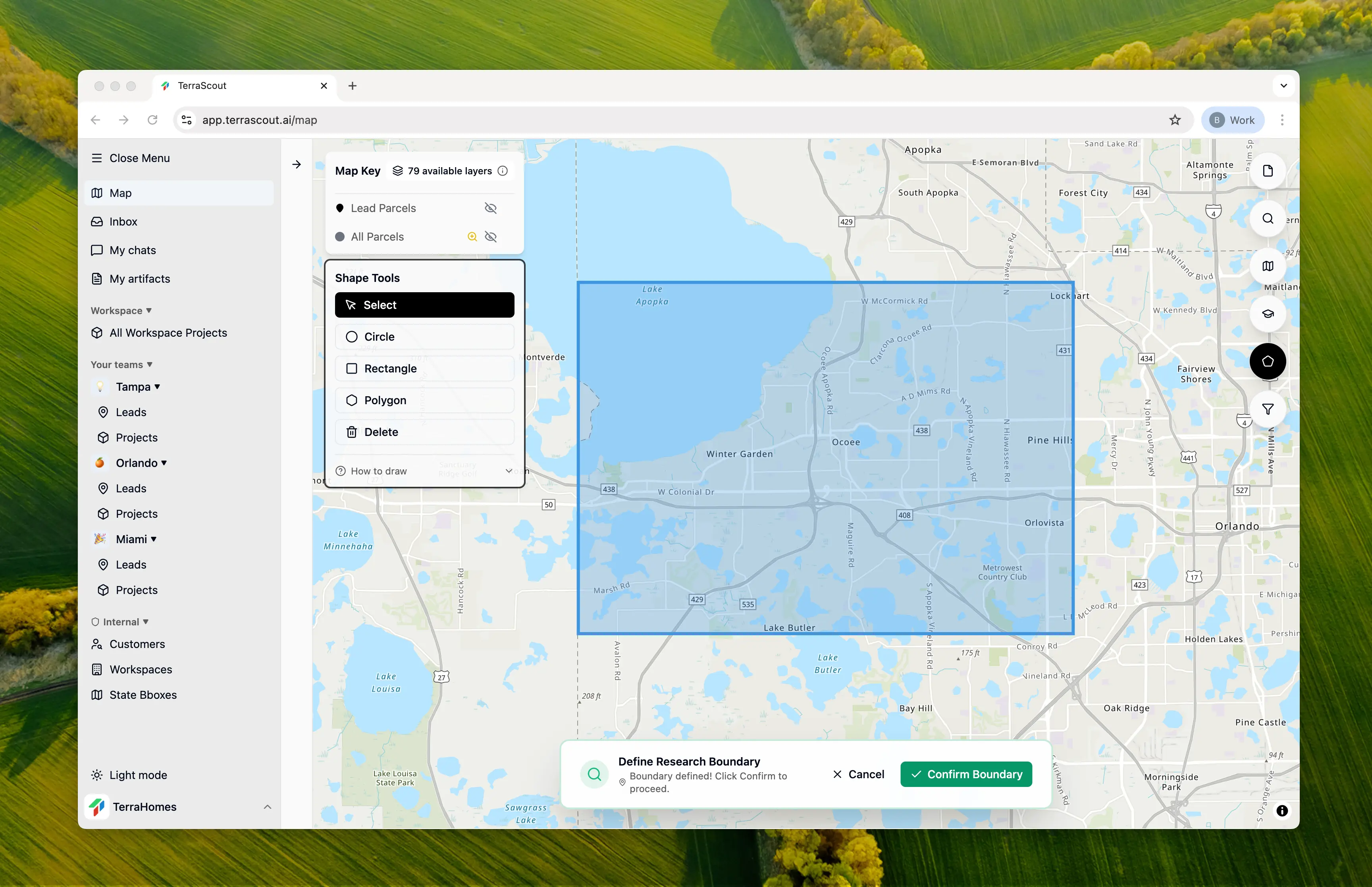
Step 2: Ask the Question
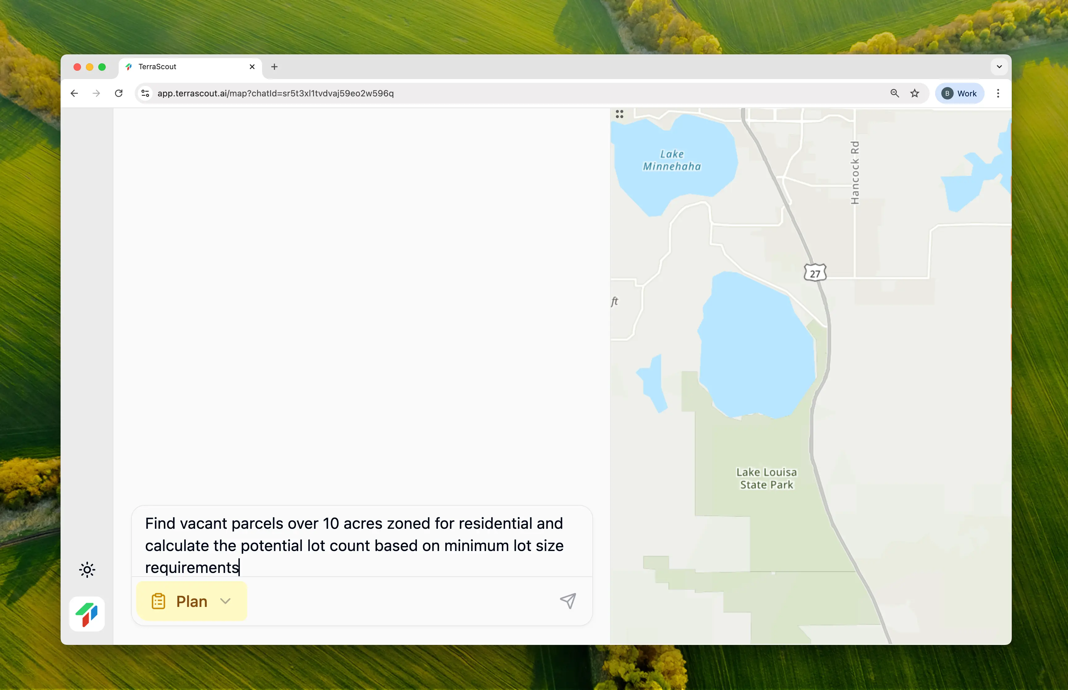
Find vacant parcels over 10 acres zoned for residential and calculate the potential lot count based on minimum lot size requirementsThis isn’t just a filter query—it requires:
- Finding qualifying parcels
- Researching minimum lot sizes for each zoning district
- Applying the correct municipal standards
- Calculating gross and net lot yields
Step 3: Review the Research Plan
Ploti researches the relevant ordinances for each municipality in your boundary: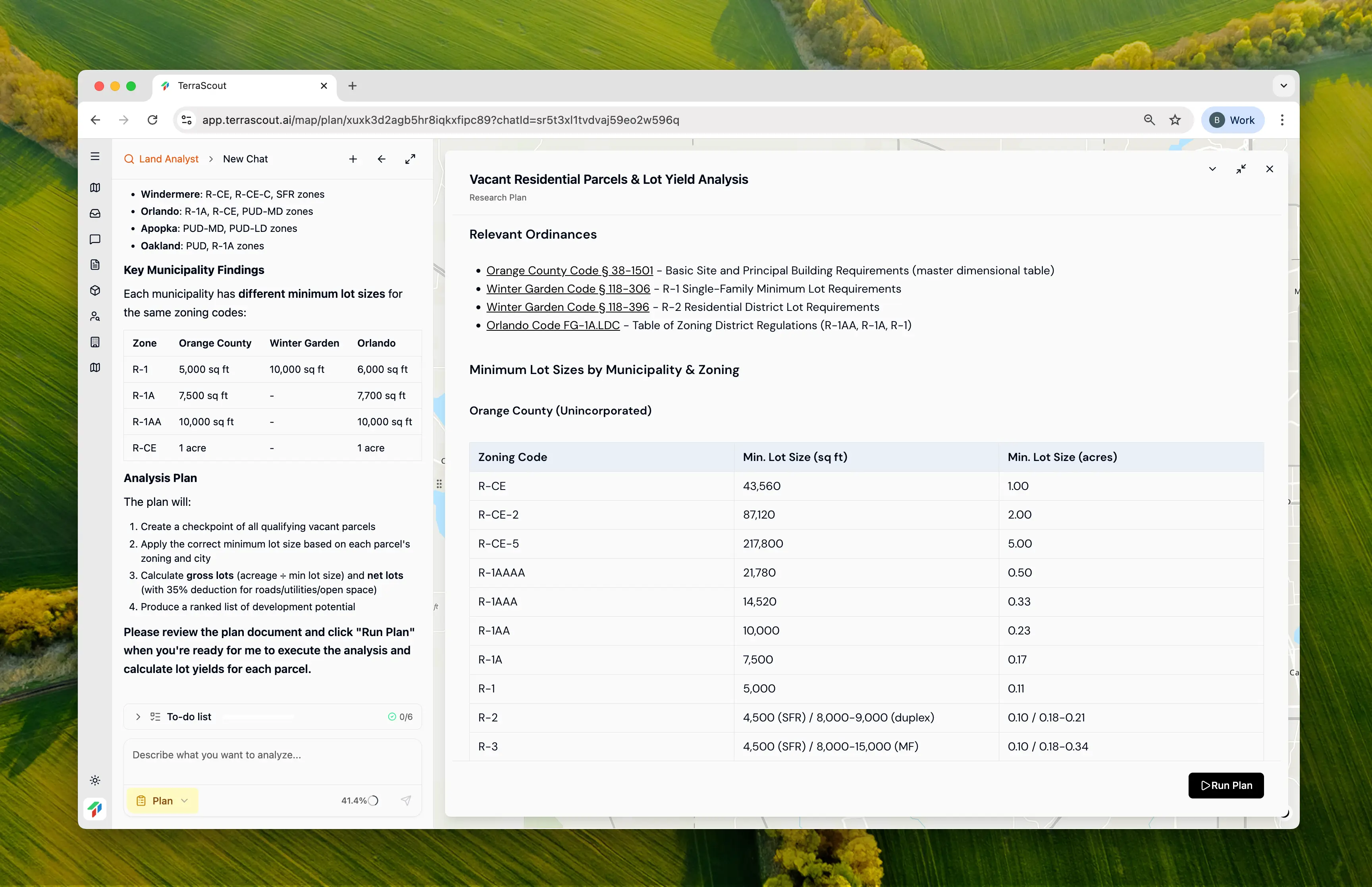
| Zone | Orange County | Winter Garden | Orlando |
|---|---|---|---|
| R-1 | 5,000 sq ft | 10,000 sq ft | 6,000 sq ft |
| R-1A | 7,500 sq ft | - | 7,700 sq ft |
| R-1AA | 10,000 sq ft | - | 10,000 sq ft |
| R-CE | 1 acre | - | 1 acre |
| PUD | ~5,000 sq ft | ~5,000 sq ft | ~5,000 sq ft |
| A-1 | 21,780 sq ft | 21,780 sq ft | - |
Step 4: Review the Results
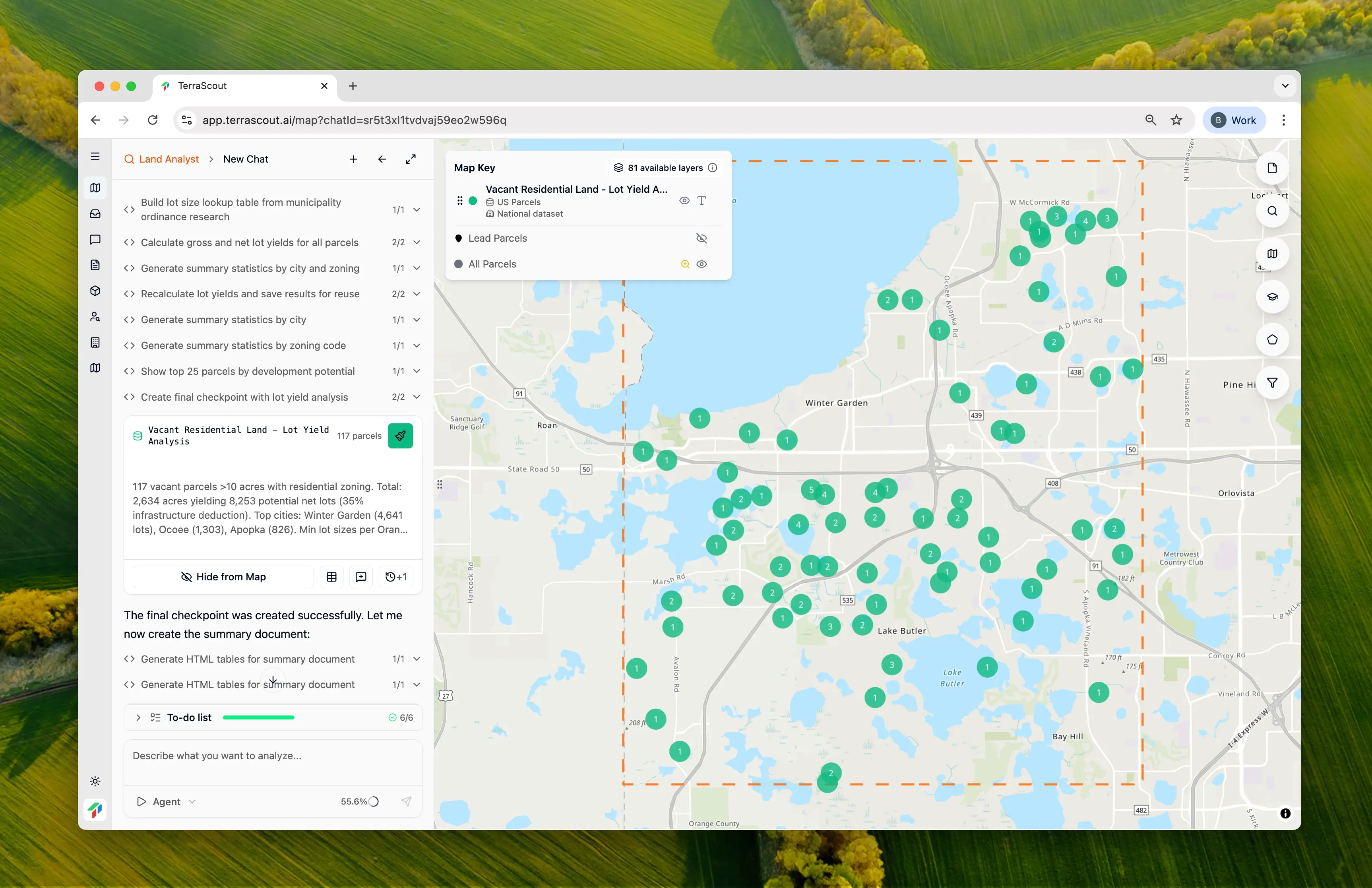
| Metric | Value |
|---|---|
| Total Parcels | 117 |
| Total Acreage | 2,633.7 acres |
| Gross Lot Yield | 12,785 lots |
| Net Lot Yield (65% efficiency) | 8,253 lots |
Step 5: Review the Feasibility Document
Ploti generates a detailed feasibility document with full analysis: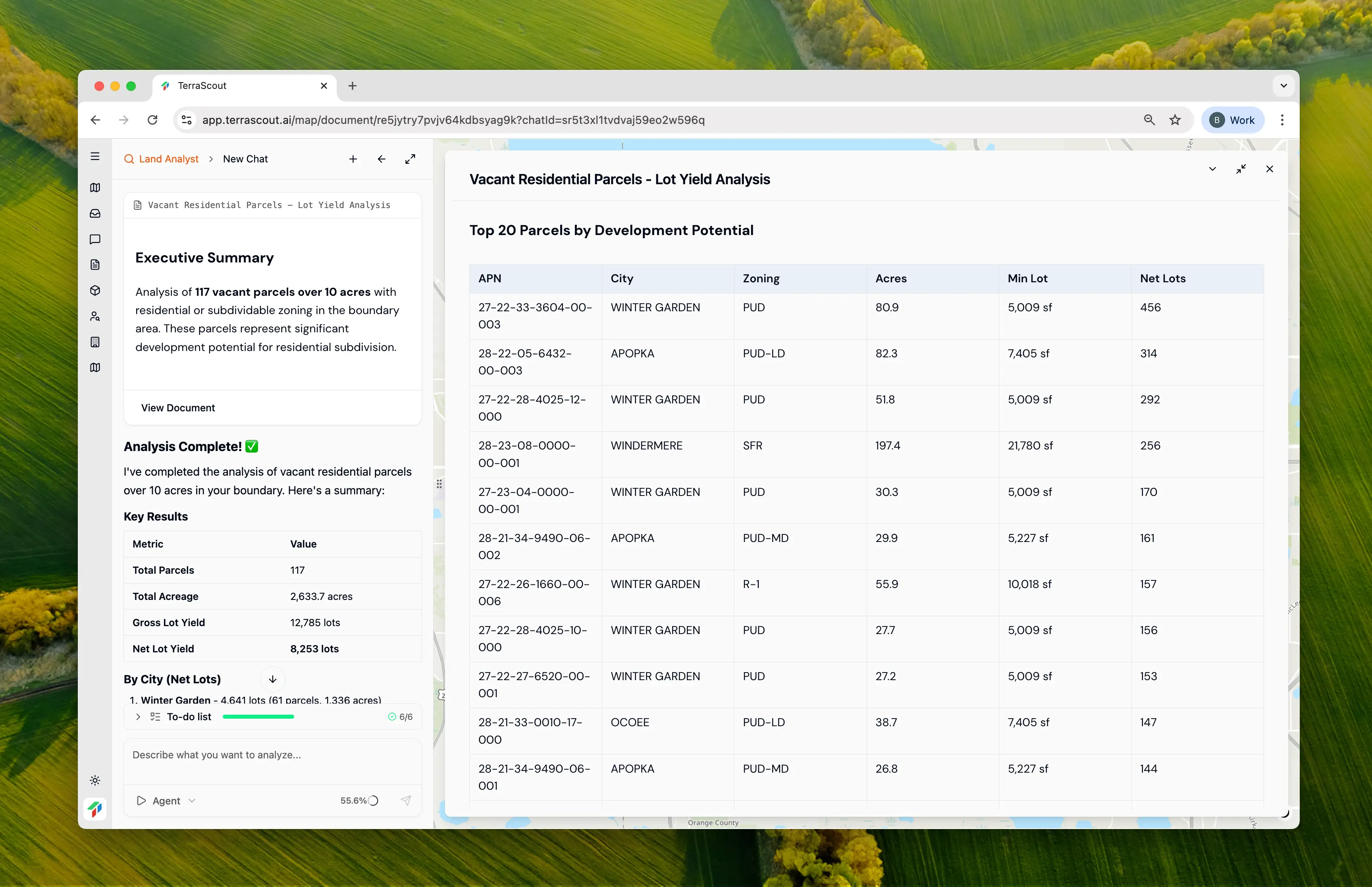
| City | Parcels | Acres | Net Lots |
|---|---|---|---|
| Winter Garden | 61 | 1,336.2 | 4,641 |
| Ocoee | 19 | 333.4 | 1,303 |
| Apopka | 6 | 177.6 | 826 |
| Windermere | 15 | 499.2 | 583 |
| Orlando | 11 | 194.9 | 515 |
| Oakland | 4 | 72.4 | 360 |
| APN | City | Zoning | Acres | Net Lots |
|---|---|---|---|---|
| 27-22-33-3604-00-003 | Winter Garden | PUD | 80.9 | 456 |
| 28-22-05-6432-00-003 | Apopka | PUD-LD | 82.3 | 314 |
| 27-22-28-4025-12-000 | Winter Garden | PUD | 51.8 | 292 |
| 28-23-08-0000-00-001 | Windermere | SFR | 197.4 | 256 |
| 27-23-04-0000-00-001 | Winter Garden | PUD | 30.3 | 170 |
Step 6: View Cited Sources
The document includes citations to the specific ordinance sections used: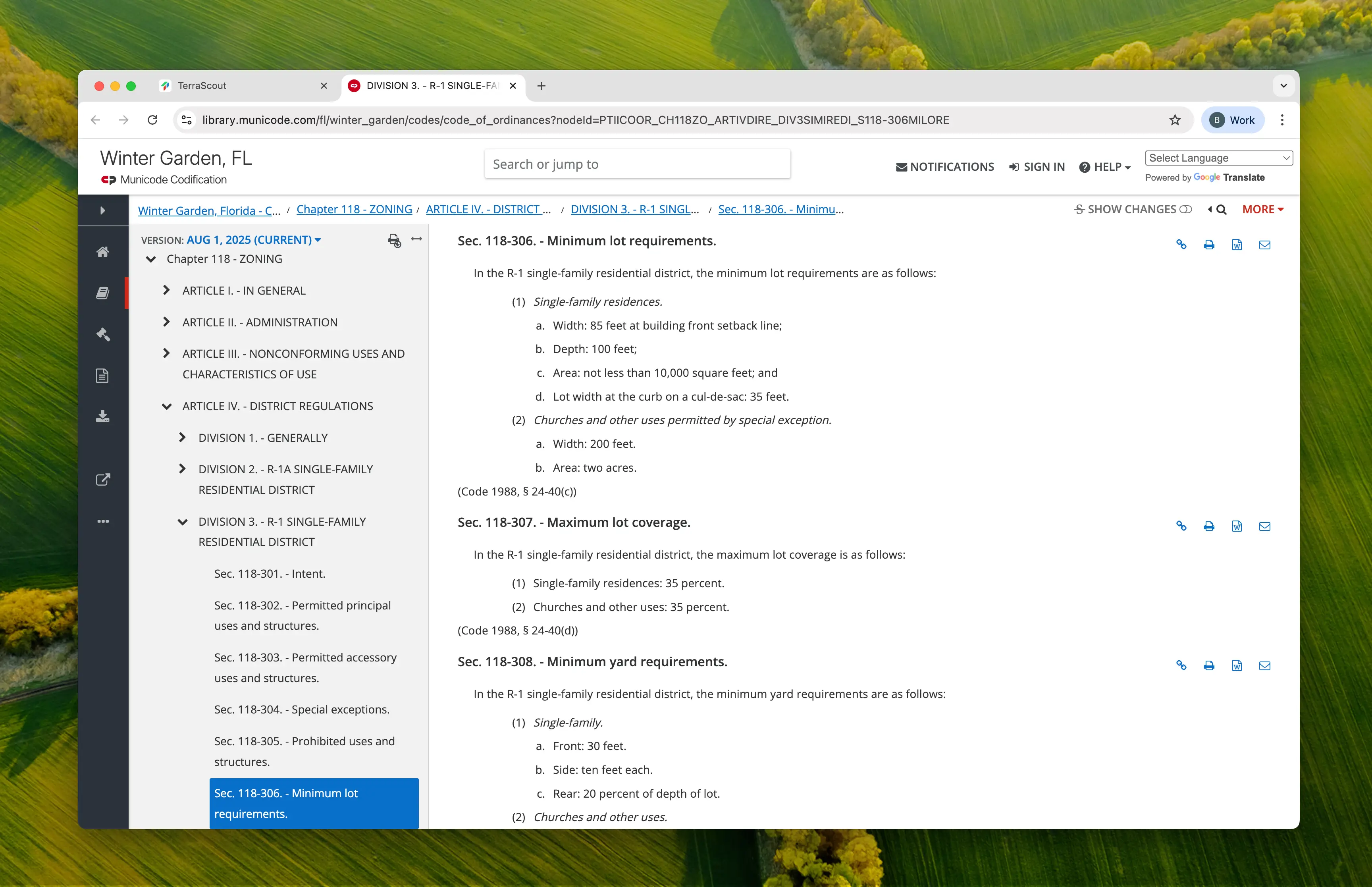
- Orange County Code § 38-1501 - Basic Site and Principal Building Requirements
- Winter Garden Code § 118-306 - R-1 Single-Family Minimum Lot Requirements
- Orlando Code FG-1A.LDC - Table of Zoning District Regulations
Step 7: Refine Through Conversation
We asked a follow-up question:Can you show me just the top 20 on the map?
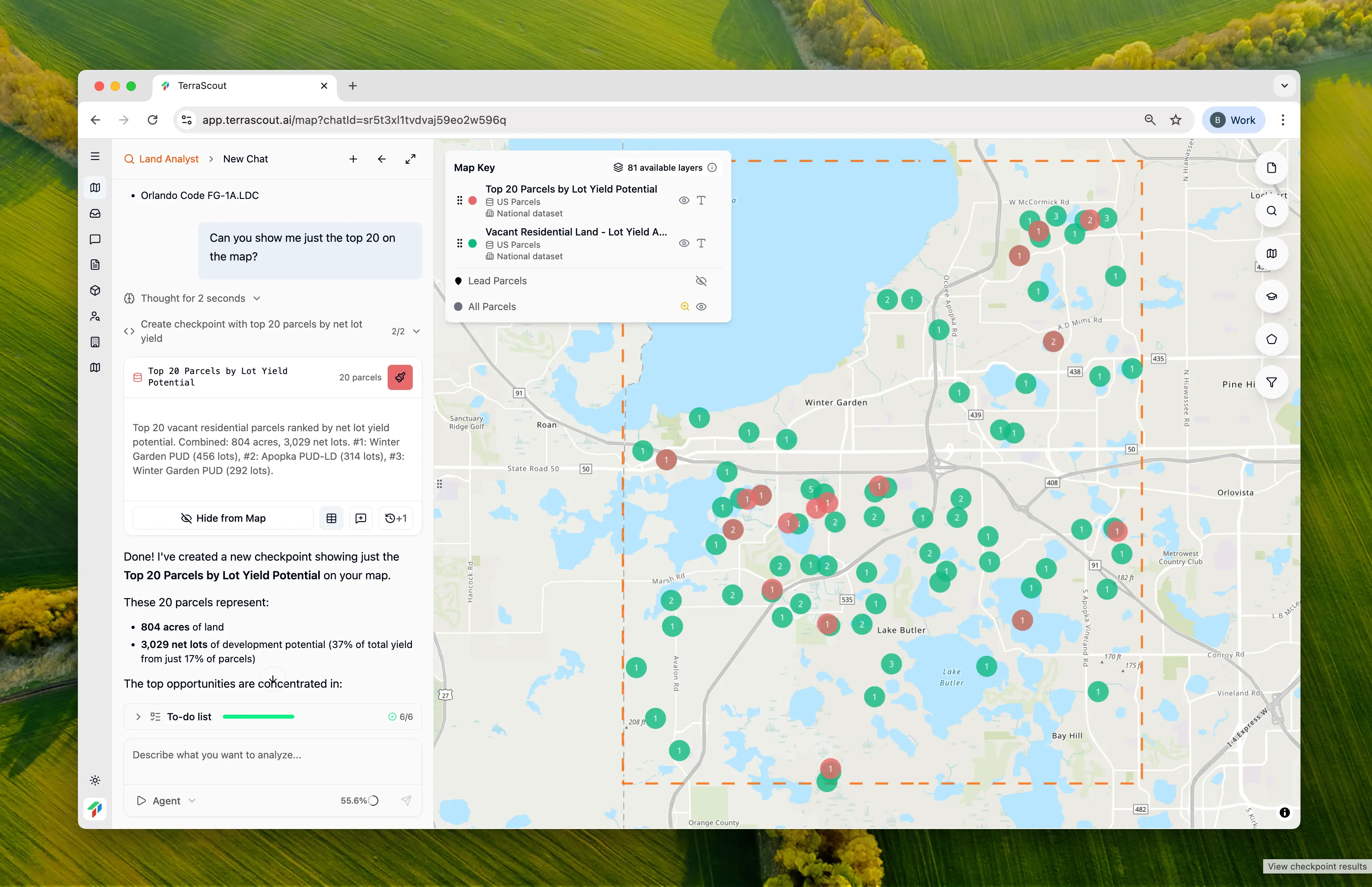
- 804 acres of land
- 3,029 net lots (37% of total yield from just 17% of parcels)
- Concentrated in Winter Garden (11), Apopka (3), Ocoee (3), Windermere (2), Oakland (1)
Important Caveats
This analysis provides estimates based on standard zoning requirements, but several factors affect accuracy: PUD (Planned Unit Development) Zones — PUD zoning doesn’t have fixed lot sizes. Each PUD has an approved site plan that defines the specific development standards. The estimates here (~5,000 sq ft) are conservative assumptions. For accurate analysis of PUD parcels, upload the approved PUD documents to the chat and ask Ploti to analyze them directly. Agricultural Zones (A-1, A-2) — Agricultural parcels are included assuming they could be subdivided at 0.5 acre lots per county code, but most would require rezoning to residential before subdivision. Treat these as “potential” rather than “ready-to-develop.” HOA/Common Area Parcels — Some results may include HOA common areas that appear as separate parcels but aren’t independently developable. Verify ownership and deed restrictions. Net Lot Deduction — The 35% deduction is an industry rule of thumb. Actual infrastructure requirements vary by jurisdiction, site topography, and stormwater needs. Some sites may lose 25%, others 45%. For the most accurate analysis on a specific parcel, provide Ploti with the approved PUD documents, site surveys, or preliminary engineering reports and ask for a refined calculation.Why This Is Different
This analysis demonstrates capabilities that go beyond filtering:| Traditional GIS | Ploti |
|---|---|
| Filter parcels by size and zoning | Same filtering capability |
| Look up lot sizes manually for each zone | Automatic ordinance research |
| Build spreadsheet with calculations | Calculations built into results |
| One parcel at a time | 117 parcels analyzed simultaneously |
| Generic assumptions | Municipality-specific standards |
The Time Savings
Without Ploti, this analysis would require:- Identifying vacant residential parcels over 10 acres
- Determining which municipality each parcel is in
- Researching minimum lot sizes for each zoning district in each municipality
- Building a lookup table of zoning → lot size by city
- Calculating gross lot yield for each parcel
- Applying gross-to-net deductions
- Sorting and ranking by development potential
- Compiling into a usable report
Tips
- For PUD parcels, download the approved PUD documents from the county and upload them to Ploti for precise lot size analysis
- Net lot yields assume 35% deduction—ask Ploti to adjust if you know local requirements differ
- Agricultural (A-1) parcels show potential but would need rezoning; factor in timeline and risk
- Always verify calculations with the municipality before making offers
- Check for wetlands, flood zones, and other constraints that reduce buildable area
Other Example Prompts
Specific Parcel Analysis
Calculate the lot yield for this 25-acre parcel based on its R-1A zoningAnalyze a specific property you’re considering.
Density Comparison
Compare the lot yield potential of R-1 vs R-2 zoning for parcels over 10 acresUnderstand the impact of zoning on development potential.
Infrastructure-Ready Sites
Find vacant parcels over 10 acres with residential zoning that have water and sewer service and calculate lot yieldsAdd utility verification to the feasibility analysis.
High-Yield Opportunities
Find the 10 vacant residential parcels with the highest lot yield potential in this areaJump straight to the best opportunities.