The Opportunity
Last-mile delivery facilities need:- Smaller footprints (1-5 acres vs 40+ for regional distribution)
- Proximity to residential population centers
- Light industrial zoning allowing warehousing/distribution
- Multiple access points for delivery vehicle routing
- Located inside the urban core, not on highway periphery
Walkthrough: Finding Sites Near Customers
Let’s find smaller industrial sites for a last-mile delivery facility. We need 1-5 acre parcels with light industrial zoning, located within 1 mile of high-density residential areas.Step 1: Select Your Search Area
Draw a boundary around your target market. In this example, we drew an area spanning Orlando, Winter Garden, Ocoee, and Oakland—covering the residential population centers you want to serve.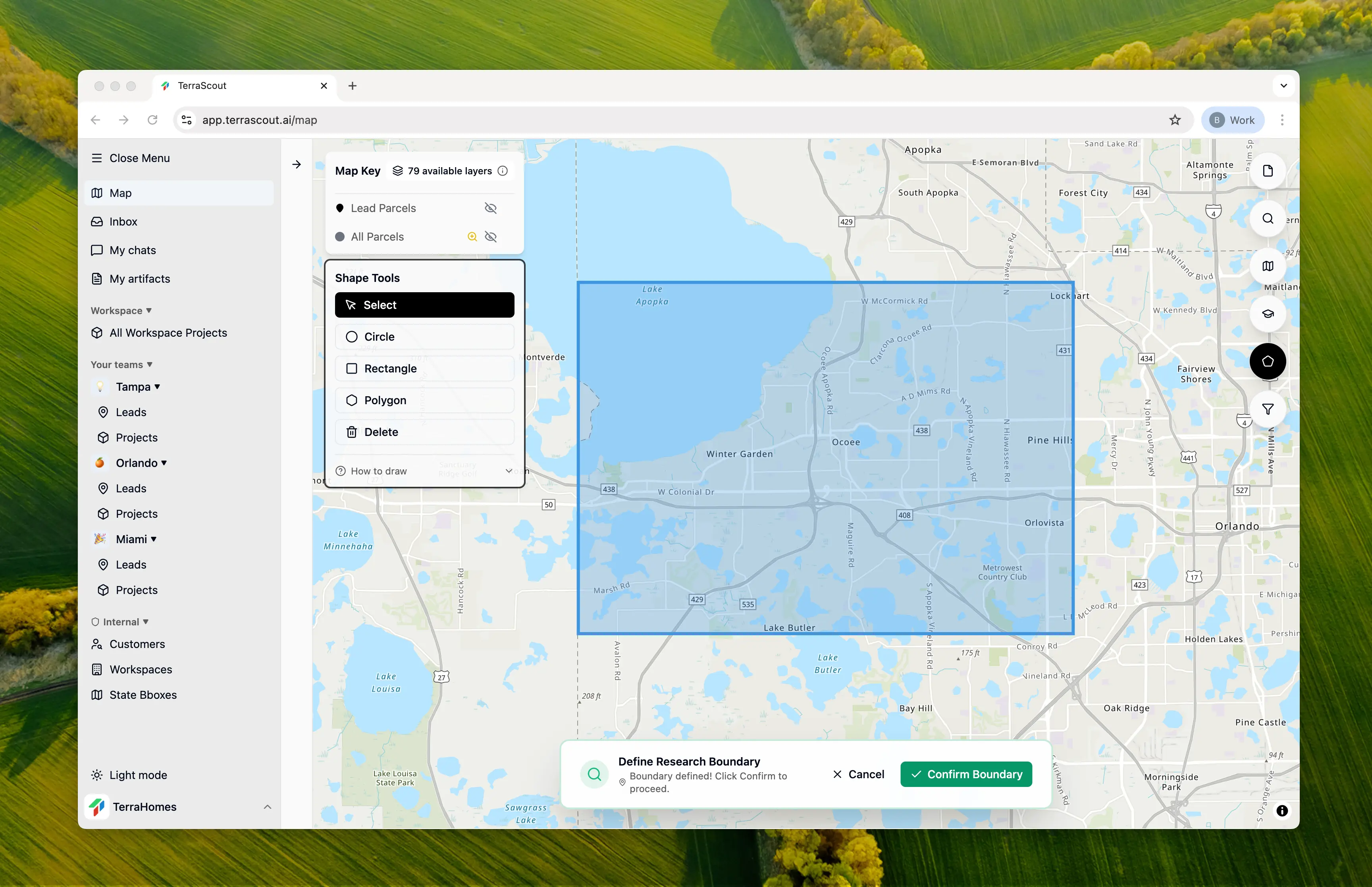
Step 2: Ask the Question
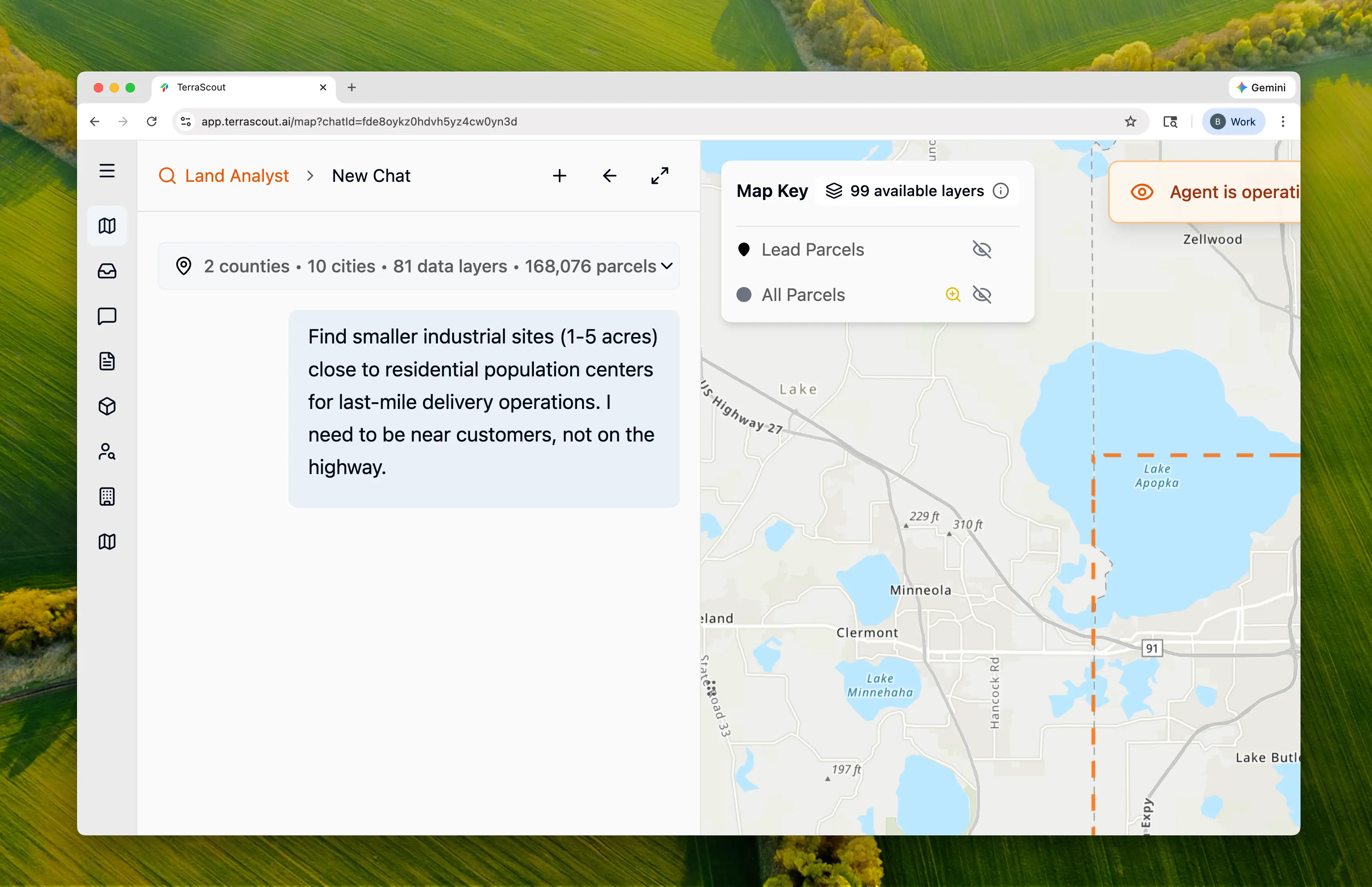
Find smaller industrial sites (1-5 acres) close to residential population centers for last-mile delivery operations. I need to be near customers, not on the highway.This triggers a different analysis than typical industrial searches:
- Small parcel filtering (1-5 acres instead of 40+)
- Residential density mapping
- Proximity analysis to population centers
- Light industrial zoning prioritization
Step 3: Watch the Research
Ploti recognizes that last-mile delivery has opposite requirements from regional distribution and researches light industrial zoning codes for each jurisdiction: Industrial Zoning Codes Found:| Municipality | Industrial Codes | Best for Last-Mile |
|---|---|---|
| Orlando | I-P, I-G, I-C | I-P, I-G (light industrial) |
| Orange County | IND-1, IND-2, IND-4 | IND-2 (light industrial) |
| Ocoee | I-1, I-2, PUD-IND | I-1 (restricted mfg/warehousing) |
| Winter Garden | I-1, I-2 | I-1 (light industrial) |
Step 4: Review the Plan
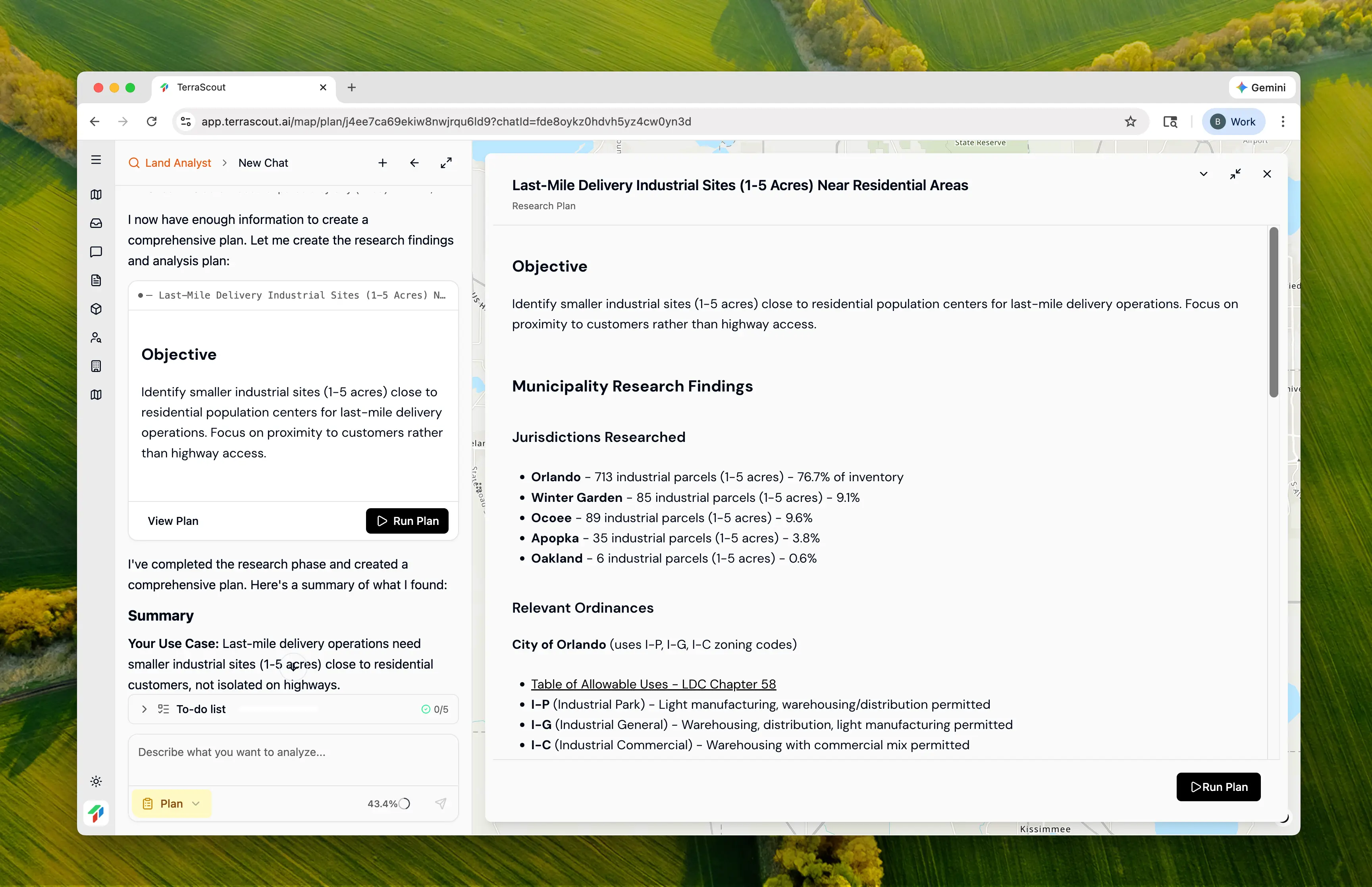
- Create base industrial checkpoint (1-5 acres)
- Create residential density checkpoint (R-3, PUD-HD, multi-family zones)
- Spatial proximity analysis—find industrial within 1 mile of residential centers
- Filter by light industrial zoning (I-P, I-G, I-1, IND-2)
- Create final checkpoint with supporting residential context layer
- Orlando LDC Chapter 58 — Table of Allowable Uses (I-P, I-G permit warehousing/distribution)
- Orange County Sec. 38-1002 — I-4 Industrial District Permitted Uses
- Ocoee Article V — Land Use & Density Regulations (I-1: enclosed buildings, attractive architecture)
- Winter Garden Division 12 — I-1 Light Industrial & Warehousing District
Step 5: Run the Analysis
Click Run Plan to execute. Ploti creates checkpoints at each filtering step: Progressive Filtering:| Step | Filter | Count |
|---|---|---|
| 1 | Industrial parcels (1-5 acres) | 930 |
| 2 | Residential population centers identified | 5,515 parcels (~275,000 housing units) |
| 3 | Industrial within 1 mile of residential | 581 |
| 4 | Light industrial zoning only | 499 |
Step 6: Review the Results
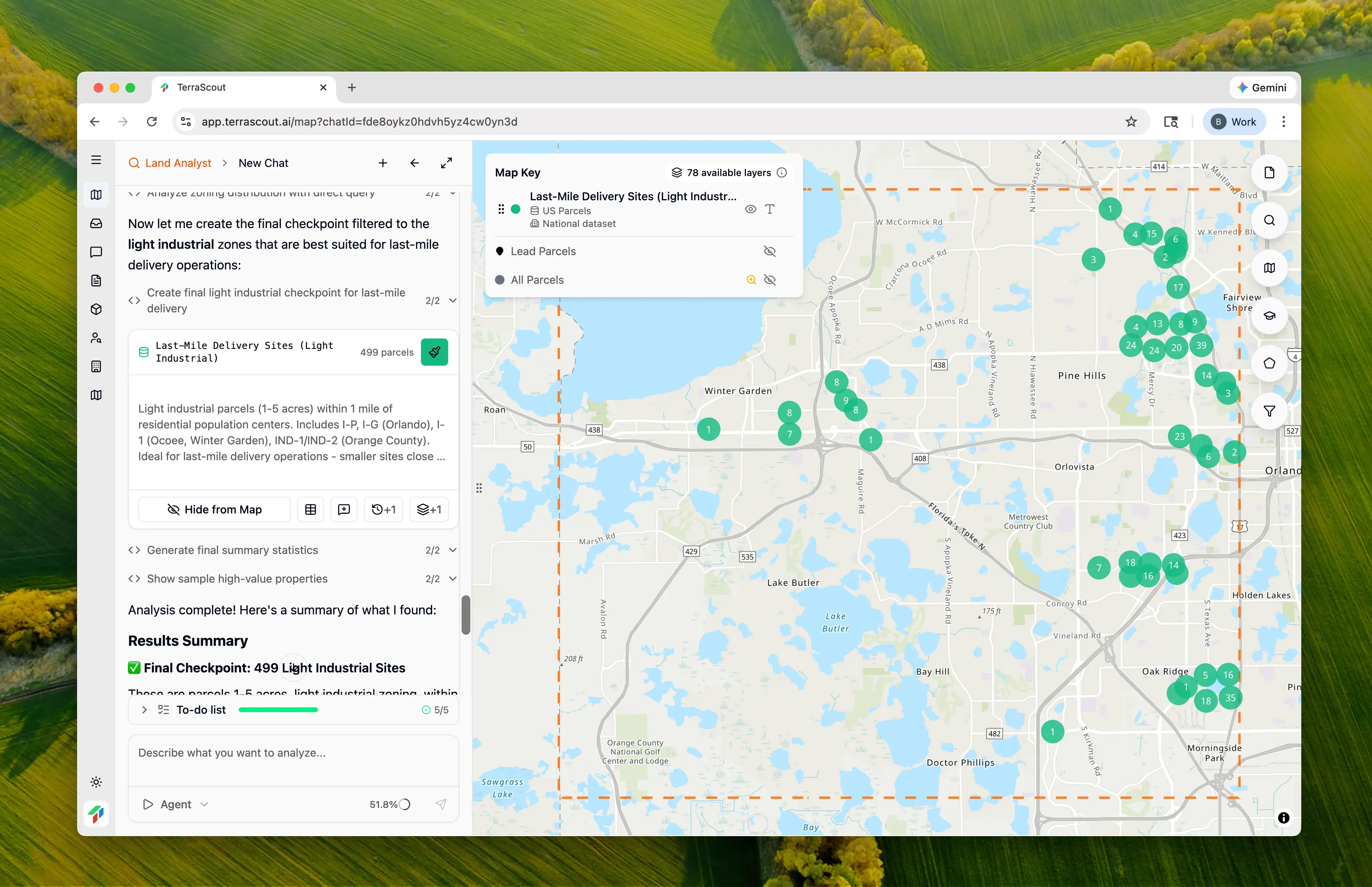
| City | Sites | % of Total | Primary Zoning |
|---|---|---|---|
| Orlando | 457 | 92% | I-P, I-G, IND-2 |
| Ocoee | 26 | 5% | I-1 |
| Winter Garden | 16 | 3% | I-1 |
Step 7: Examine Site Details
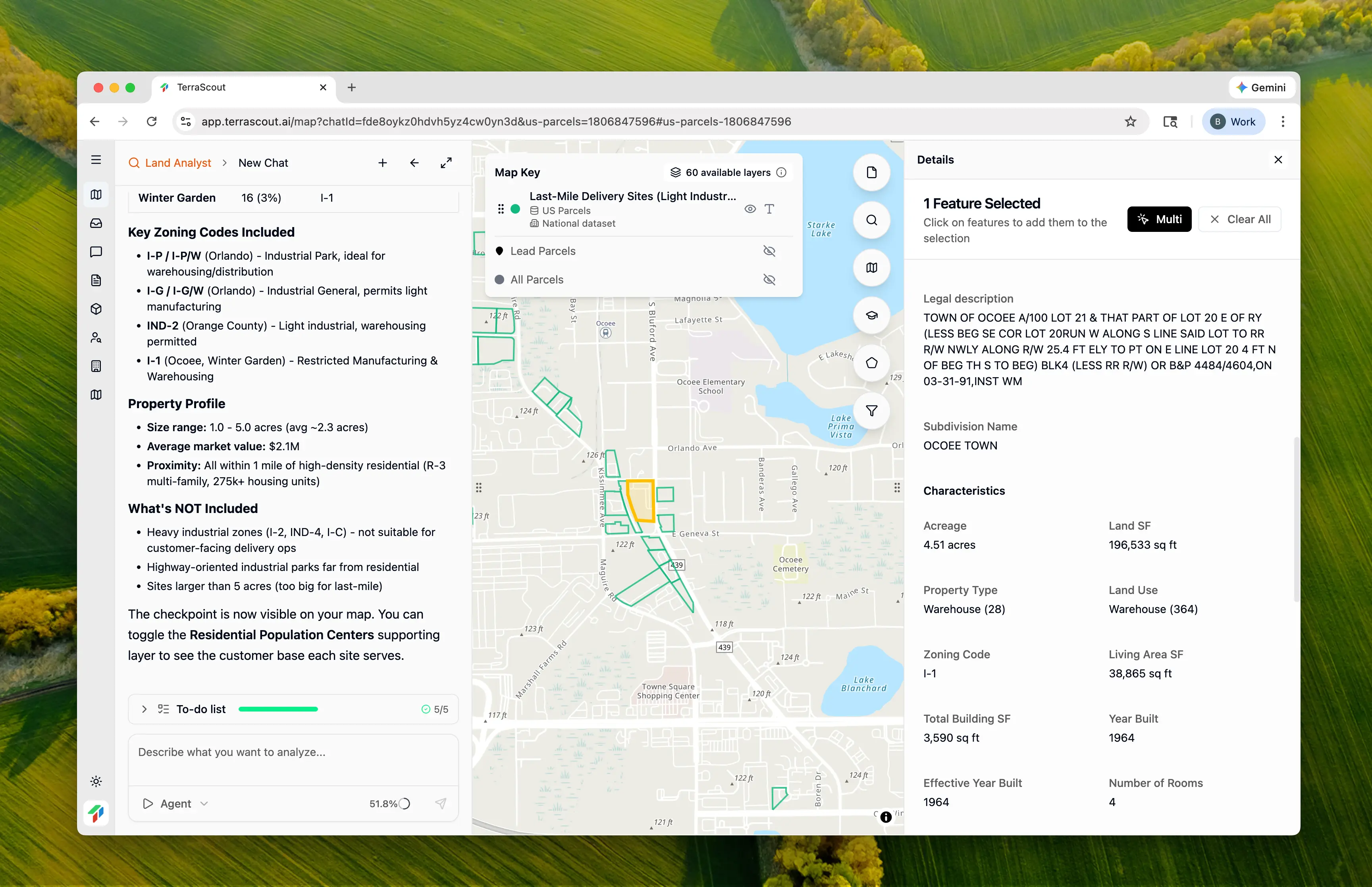
- Parcel size and dimensions
- Zoning code and permitted uses
- Owner information
- Proximity to residential areas (visible by toggling the population centers layer)
- Heavy industrial zones (I-2, IND-4, I-C)—not suitable for customer-adjacent operations
- Highway-oriented industrial parks far from residential
- Sites larger than 5 acres (too big for last-mile)
- Sites more than 1 mile from population centers
Step 8: Toggle the Residential Layer
The analysis created a supporting checkpoint showing residential population centers. Toggle this layer to:- Visualize customer density around each industrial site
- Identify sites serving the highest population
- Understand delivery route implications
- Spot gaps in coverage
Why This Matters
This analysis demonstrates inverted site selection logic:- Opposite of typical industrial search — Small sites near customers vs large sites near highways
- Residential proximity as the key filter — Not just “is it industrial” but “is it near the people I’m delivering to”
- Population center mapping — 275,000 housing units mapped to understand customer base
- Light industrial filtering — Excluded heavy industrial zones inappropriate for urban delivery
- Supporting context layer — Residential checkpoint shows the “why” behind each site
- Researching light vs heavy industrial zoning distinctions
- Mapping high-density residential areas
- Performing spatial buffer analysis
- Cross-referencing industrial parcels against residential proximity
- Understanding which zones allow delivery operations without neighborhood conflicts
Taking It Further
With 499 sites identified, you can refine further:Which sites have the best road access for delivery vans?Factor in traffic patterns and multiple egress points.
Show me sites in areas with the highest residential densityPrioritize by customer concentration.
Which of these sites are currently vacant?Focus on available inventory vs occupied buildings.
What are the development standards for I-P zoning in Orlando?Research setbacks, loading requirements, and screening for delivery operations.
Key Insights
Why Last-Mile Needs Different Sites
Regional distribution centers optimize for:- Highway interchange proximity
- Large truck access
- 40-100+ acre parcels
- Buffer from residential
- Residential proximity (within delivery radius)
- Van/sprinter access (not semi-trucks)
- 1-5 acre parcels
- Integration with urban fabric
Light Industrial vs Heavy Industrial
| Characteristic | Light Industrial (I-P, I-G, I-1) | Heavy Industrial (I-2, IND-4) |
|---|---|---|
| Building type | Enclosed, attractive | Open operations allowed |
| Traffic | Vans, light trucks | Semi-trucks, heavy equipment |
| Noise/odor | Minimal | May generate impacts |
| Residential buffer | Not required | Often required |
| Last-mile suitability | ✓ Ideal | ✗ Not appropriate |
The 92% Orlando Concentration
Orlando dominates the results (457 of 499 sites) because:- Highest residential density in the boundary
- Most light industrial inventory (I-P, I-G zones)
- Urban fabric allows industrial/residential proximity
- Other cities have more highway-oriented industrial
Tips
- 1 mile is the sweet spot — Close enough for efficient delivery routes, far enough to avoid residential zone conflicts
- Light industrial only — Heavy industrial zones have uses that create neighbor complaints
- Check van access — Last-mile facilities need vehicle access appropriate for sprinters and vans, not semis
- Consider operating hours — Light industrial zones often have fewer restrictions on early morning operations
- Multiple sites may work — Instead of one large facility, multiple 1-2 acre sites can improve coverage
- Toggle the residential layer — Understanding customer density helps prioritize sites
Other Example Prompts
Coverage Gap Analysis
I already have a delivery facility in downtown Orlando. Find industrial sites in areas I’m NOT currently covering well.Identify underserved residential areas and industrial sites to fill gaps.
Competing with Traffic
Find last-mile sites that avoid major commuter corridors during delivery hoursFactor in traffic patterns for delivery efficiency.
Multi-Site Strategy
I need 3-4 small industrial sites spread across the metro to minimize delivery distances. Show me optimal locations for coverage.Distribute facilities for route efficiency.
Retrofit Opportunities
Find older industrial buildings on small lots that might be available for lease as delivery hubsTarget existing buildings vs new construction.
Mixed-Use Industrial
Are there any industrial sites in mixed-use zones where I could have a customer pickup location?Find sites allowing retail/pickup alongside distribution.