The Opportunity
Retail site selection often follows anchor tenants:- Grocery stores generate consistent daily traffic
- Customers make secondary stops (QSR, pharmacy, services)
- Being near anchors without competition is the sweet spot
Walkthrough: Finding McDonald’s Sites Near Underserved Publix Stores
Let’s find potential McDonald’s locations by identifying Publix grocery stores that don’t have a McDonald’s nearby. These represent gaps where grocery traffic could support a new QSR.Step 1: Select Your Search Area
Draw a boundary around your target market. In this example, we drew an area spanning Orlando, Winter Garden, Ocoee, and Windermere—capturing major grocery-anchored retail corridors.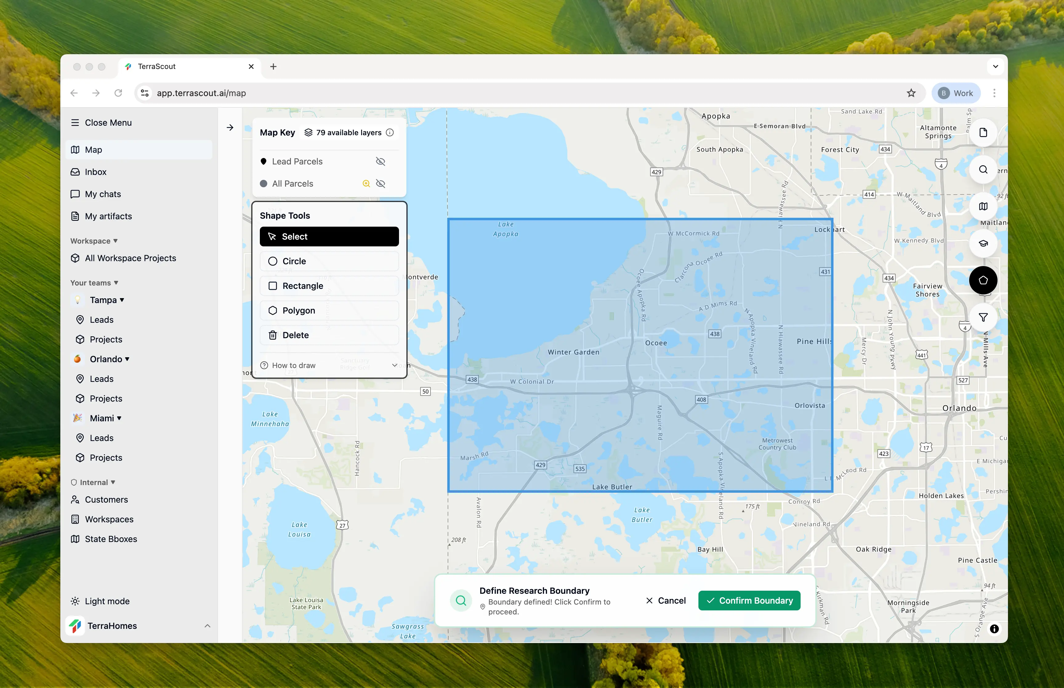
Step 2: Ask the Question
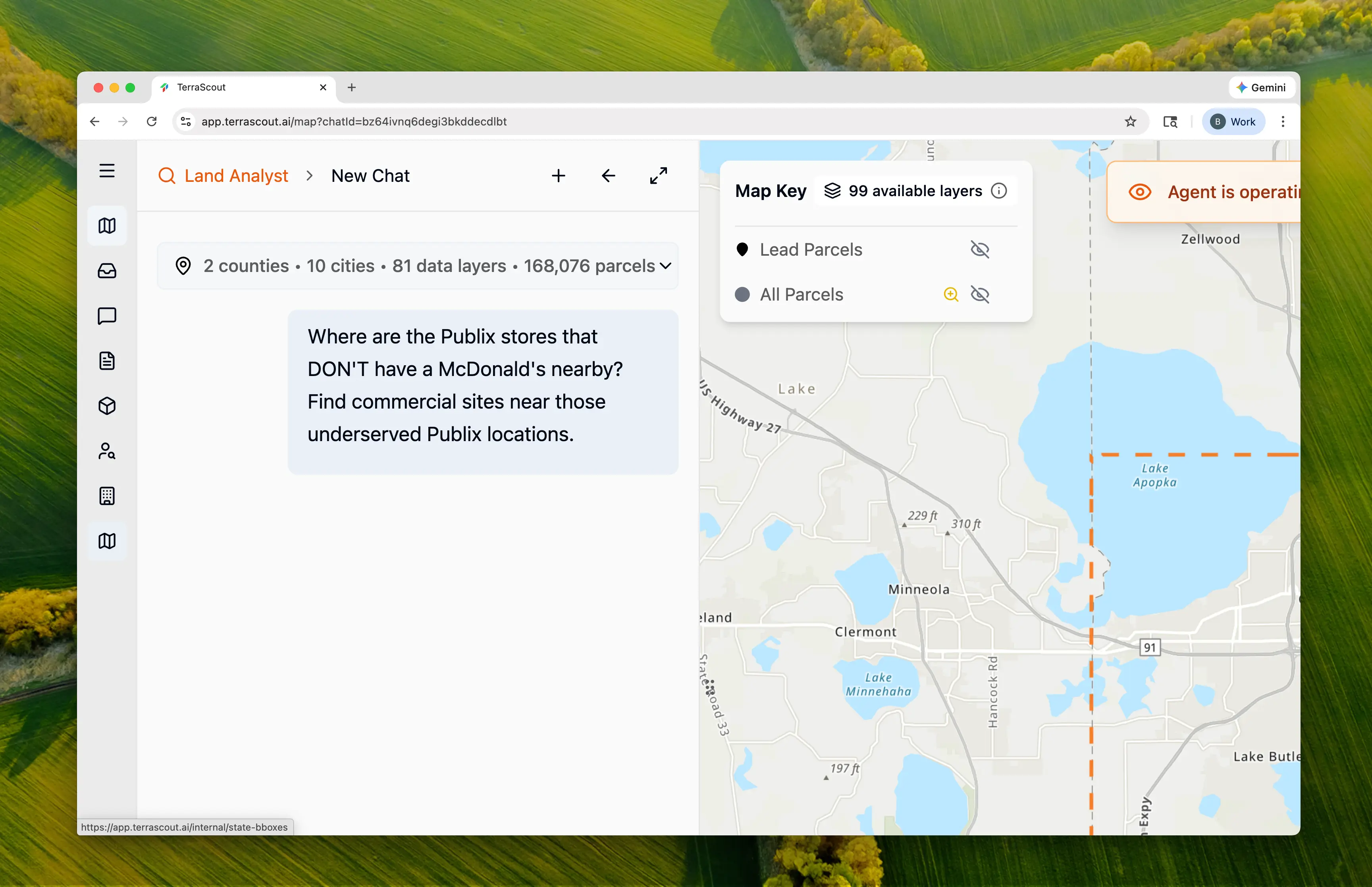
Where are the Publix stores that DON’T have a McDonald’s nearby? Find commercial sites near those underserved Publix locations.This frames the problem as gap analysis—find the anchors first, then the opportunities near them. Ploti:
- Discovers POI data for both brands
- Performs spatial exclusion analysis
- Identifies vacant commercial parcels
- Researches zoning for restaurant uses
Step 3: Watch the Discovery
Ploti found POI data and performed the gap analysis: Locations Discovered:| Brand | Count | Source |
|---|---|---|
| Publix | Multiple | OSM POI data |
| McDonald’s | 18 | OSM POI data |
| City | Coordinates | Distance to Nearest McDonald’s | Vacant Commercial Nearby |
|---|---|---|---|
| Windermere | (28.4465, -81.5614) | More than 5km | None found |
| Orlando | (28.4487, -81.4866) | More than 5km | 5 parcels (8.82 ac) |
| Orlando | (28.4908, -81.5105) | More than 5km | None found |
| Orlando | (28.5730, -81.4046) | 1.49 mi | 6 parcels (13.62 ac) |
| Ocoee | (28.5322, -81.5397) | 1.40 mi | 4 parcels (8.50 ac) |
| Orlando | (28.4877, -81.4151) | 1.22 mi | 5 parcels (28.89 ac) |
Step 4: Review the Plan
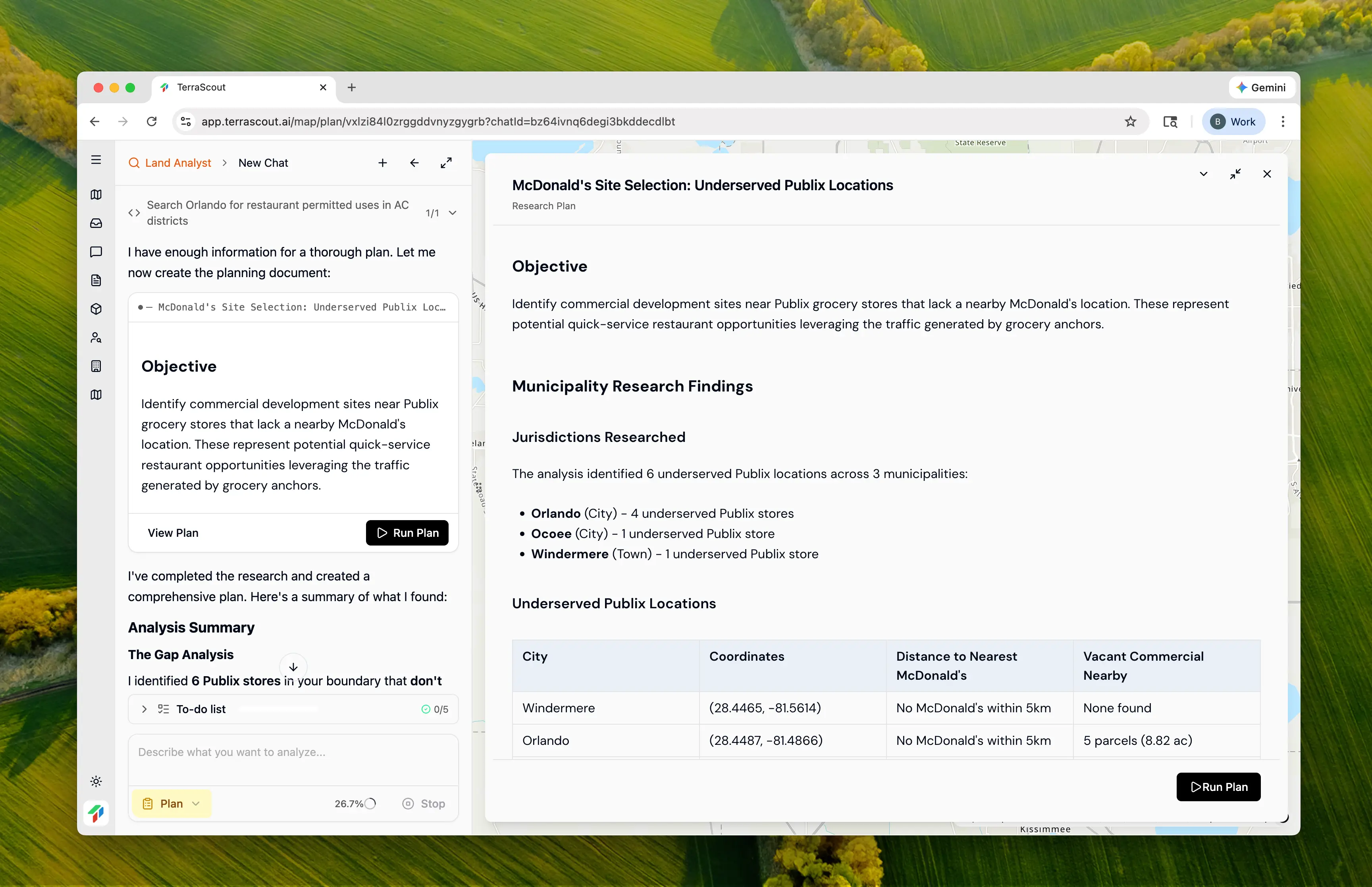
- Create checkpoint for underserved Publix locations (6 stores)
- Create checkpoint for all McDonald’s (reference layer)
- Find vacant commercial parcels in Orlando near underserved Publix
- Find vacant commercial parcels in Ocoee near underserved Publix
- Create combined checkpoint of all potential sites
- Orlando LDC Table FG-2A — Allowable uses in AC-N, AC-1, AC-2, AC-3 districts
- Sec. 58.341 — Activity Center Districts purpose and intent
- Orange County Sec. 38-851 — General Commercial Districts (C-1, C-2, C-3)
- Orange County Sec. 38-1552 — Fast food/restaurant permitted locations
- Ocoee § 5-3 — C-1, C-2, C-3, PUD-COMM district definitions
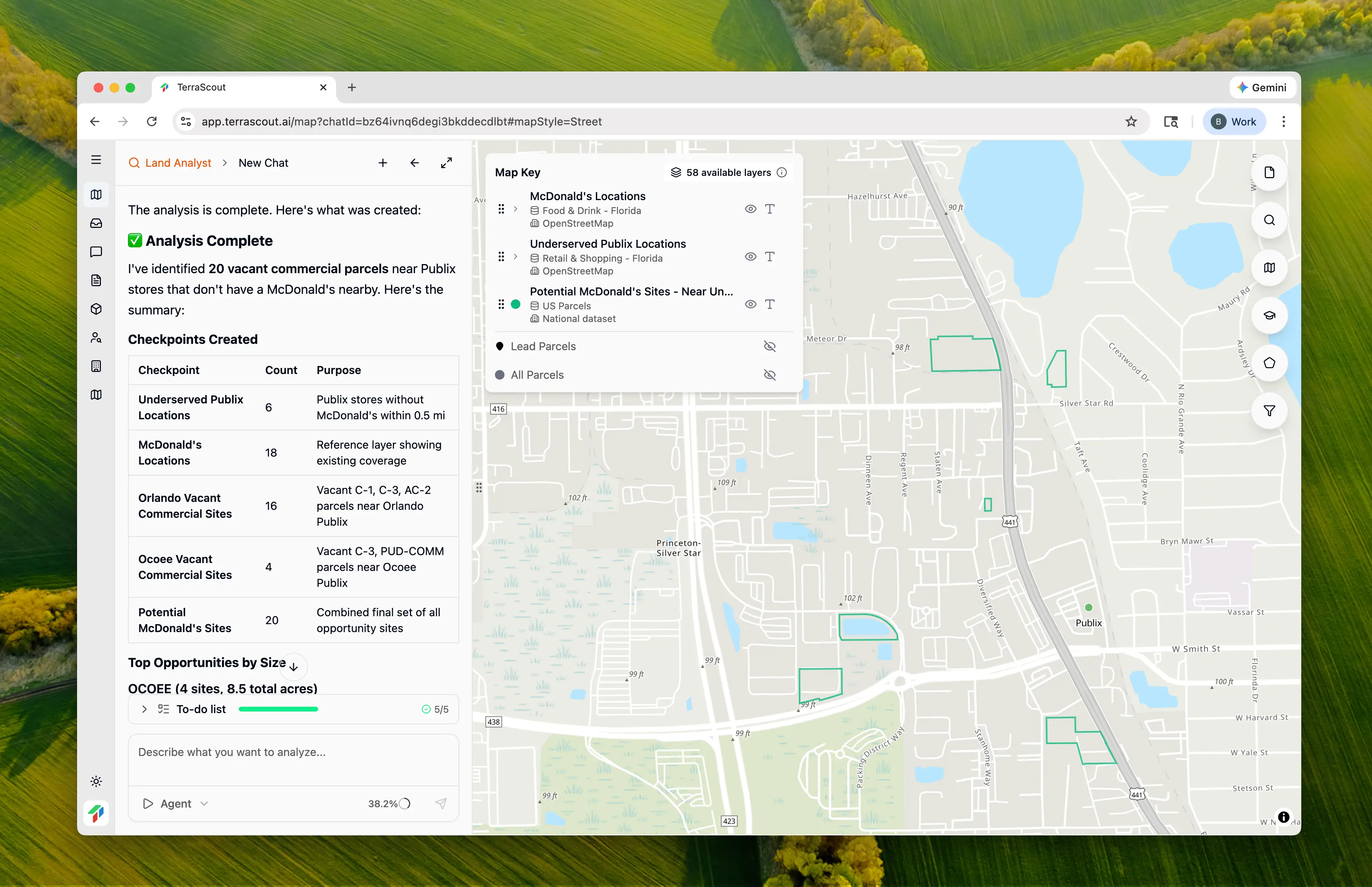
Step 5: Run the Analysis
Click Run Plan to execute. Ploti creates multiple checkpoints:| Checkpoint | Count | Description |
|---|---|---|
| Underserved Publix Locations | 6 | Publix stores without McDonald’s within 0.5 mi |
| McDonald’s Locations | 18 | Reference layer showing existing coverage |
| Orlando Vacant Commercial | 16 | C-1, C-3, AC-2 parcels near Orlando Publix |
| Ocoee Vacant Commercial | 4 | C-3, PUD-COMM parcels near Ocoee Publix |
| Potential McDonald’s Sites | 20 | Combined final set |
Step 6: Review the Results
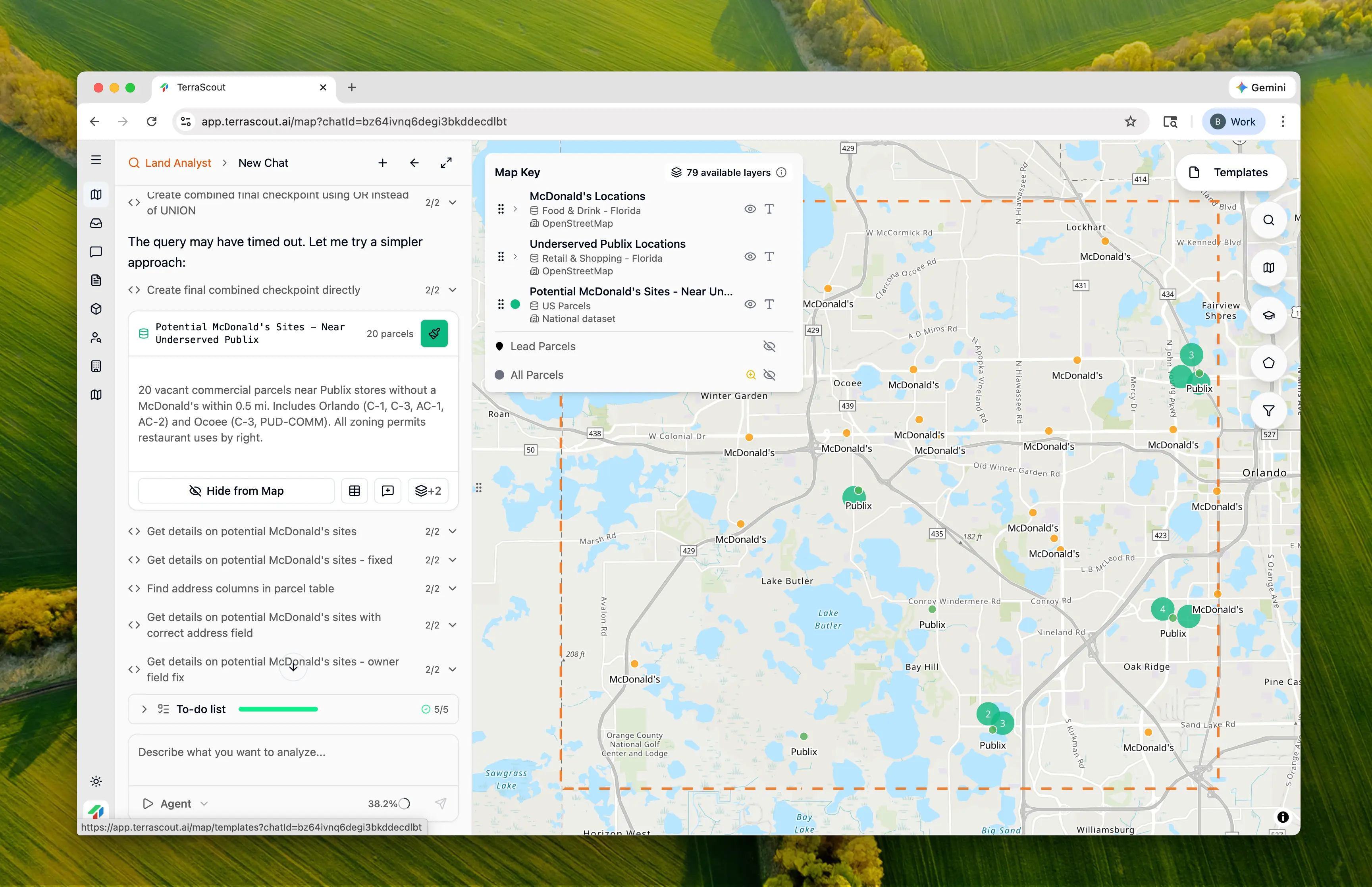
- Publix locations — The underserved anchor tenants
- McDonald’s locations — Existing coverage (to visualize the gaps)
- Vacant commercial parcels — Development opportunities
Step 7: Examine Specific Opportunities
- The Publix anchor generating traffic
- Nearby McDonald’s locations (or lack thereof)
- Available commercial parcels for development
| Location | Acres | Zoning | Address/Area |
|---|---|---|---|
| Ocoee | 4.88 | PUD-COMM | 3010 Maguire Rd (Maguire Shoppes) |
| Orlando | 13.63 | C | Timarron Dr (Millennium Parc) |
| Orlando | 11.05 | C | S John Young Pkwy |
| Orlando | 4.50 | C-3 | 3100 N Orange Blossom Trl |
| Orlando | 4.36 | C-1 | Somerset Shores Ct (Dr Phillips) |
Step 8: Understand the Zoning
Each municipality has different commercial zoning codes, but all identified parcels permit restaurant uses:| Municipality | Commercial Codes | Restaurant Permitted |
|---|---|---|
| Orlando | C-1, C-2, C-3, AC-N, AC-1, AC-2, AC-3 | By right in all codes |
| Ocoee | C-1, C-2, C-3, PUD-COMM | By right |
| Windermere | COM-TCOD | Very limited commercial |
Why This Matters
This analysis demonstrates multi-layer gap analysis:- POI data discovery — Found Publix and McDonald’s locations automatically from OSM data
- Spatial exclusion — Identified which anchors lack nearby competitors
- Vacancy filtering — Only showed parcels available for development (prop_ind=‘80’)
- Zoning verification — Confirmed restaurant uses are permitted
- Visual layering — All three datasets (Publix, McDonald’s, parcels) visible together
- Obtaining POI data for both brands
- Performing spatial buffer analysis
- Cross-referencing with parcel data
- Filtering for vacant parcels
- Researching zoning for each municipality
Taking It Further
With underserved locations identified, you can refine further:Which of these sites have the highest traffic counts?Layer in AADT data for site quality.
Show me the drive-through requirements for C-3 zoning in OrlandoResearch development standards for QSR.
Are any of these sites pad site opportunities in existing centers?Identify outparcel potential vs ground-up development.
What’s the population density within 3 miles of each site?Understand the customer base for each location.
Key Insights
Why Anchor Proximity Matters
Grocery stores like Publix generate:- Daily traffic — People shop for groceries 2-3x per week
- Predictable patterns — Morning and evening peaks
- Secondary trips — Customers add stops (coffee, lunch, pharmacy)
- Dwell time — Shoppers are already out of their cars
The 0.5-Mile Threshold
We used 0.5 miles as the “nearby” threshold because:- Walking distance for urban areas
- Quick driving distance for suburban
- Beyond 0.5 miles, customers may choose convenience over brand loyalty
- Industry standard for QSR trade area analysis
Why Some Locations Have No Sites
Two underserved Publix locations (Windermere and one Orlando location) had no vacant commercial sites nearby. This means:- Existing commercial is fully built out
- Rezoning would be required for new development
- These may be opportunity areas for existing building conversion
- Or simply not viable for new QSR development
Tips
- Toggle all layers — Seeing Publix, McDonald’s, and parcels together reveals the spatial story
- Check vacancy carefully — “Commercial zoning” doesn’t mean “available”—filter for vacant parcels
- Verify drive-through — Not all commercial zones allow drive-through; research specific requirements
- Consider pad sites — Some “vacant” parcels may be outparcels in existing centers
- Look at traffic — High anchor traffic + no competition = best opportunity
- Research lease rates — Sites near strong anchors command premium rents
Other Example Prompts
Different Anchor/Tenant Combination
Find Walgreens locations without a Starbucks nearby and show me commercial sites for a new coffee shopSame methodology, different brands.
Competitor Density Analysis
Show me areas with high Chick-fil-A density but few Popeyes locationsIdentify where competitors are winning.
Multi-Anchor Analysis
Find commercial sites near both a grocery store AND a gym but away from existing fast foodLayer multiple anchor types for site selection.
Underserved Trade Areas
Which retail centers have grocery anchors but no sit-down restaurants within the center?Find gaps within existing developments.
Drive-Through Specific
Find commercial parcels zoned for drive-through use near grocery stores without a coffee shopFocus on use-specific zoning requirements.