The Opportunity
Corporate campus and office development sites need:- Sufficient acreage for building footprint plus structured or surface parking
- Office, commercial, or mixed-use zoning (varies by municipality)
- Location outside flood hazard areas
- Minimal wetland impact to avoid costly mitigation
- Infrastructure access (water, sewer, power)
Walkthrough: Finding Corporate Campus Sites
Let’s find sites for a corporate campus—a 150,000 SF office building requiring at least 15 acres to accommodate the building plus structured parking. We need sites outside flood zones with minimal wetland impact.Step 1: Select Your Search Area
First, draw a boundary around your target market. In this example, we drew an area spanning Orlando, Winter Garden, Ocoee, and Windermere—multiple jurisdictions with different zoning codes.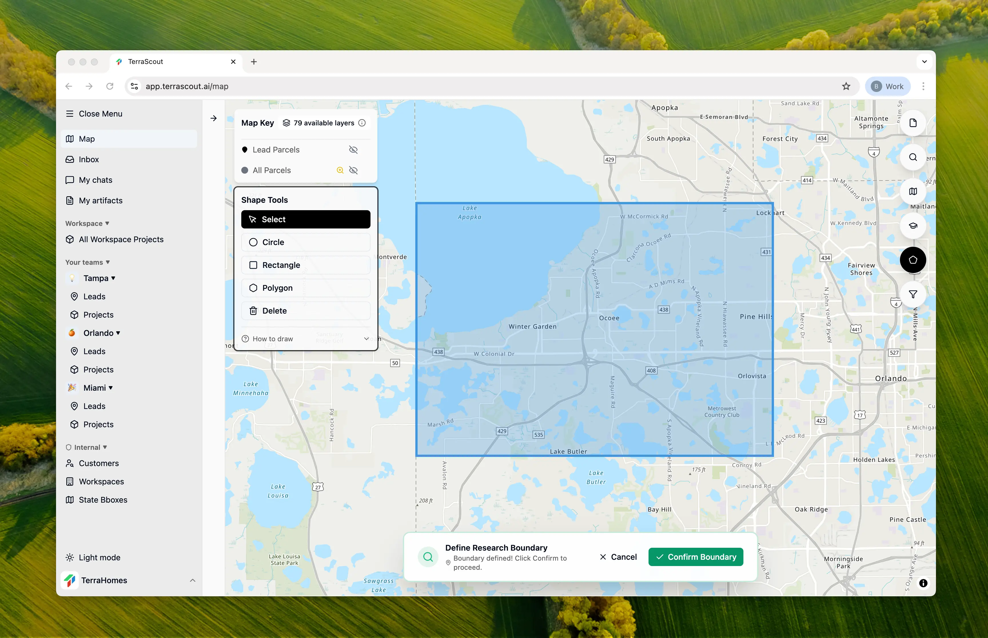
Step 2: Ask the Question
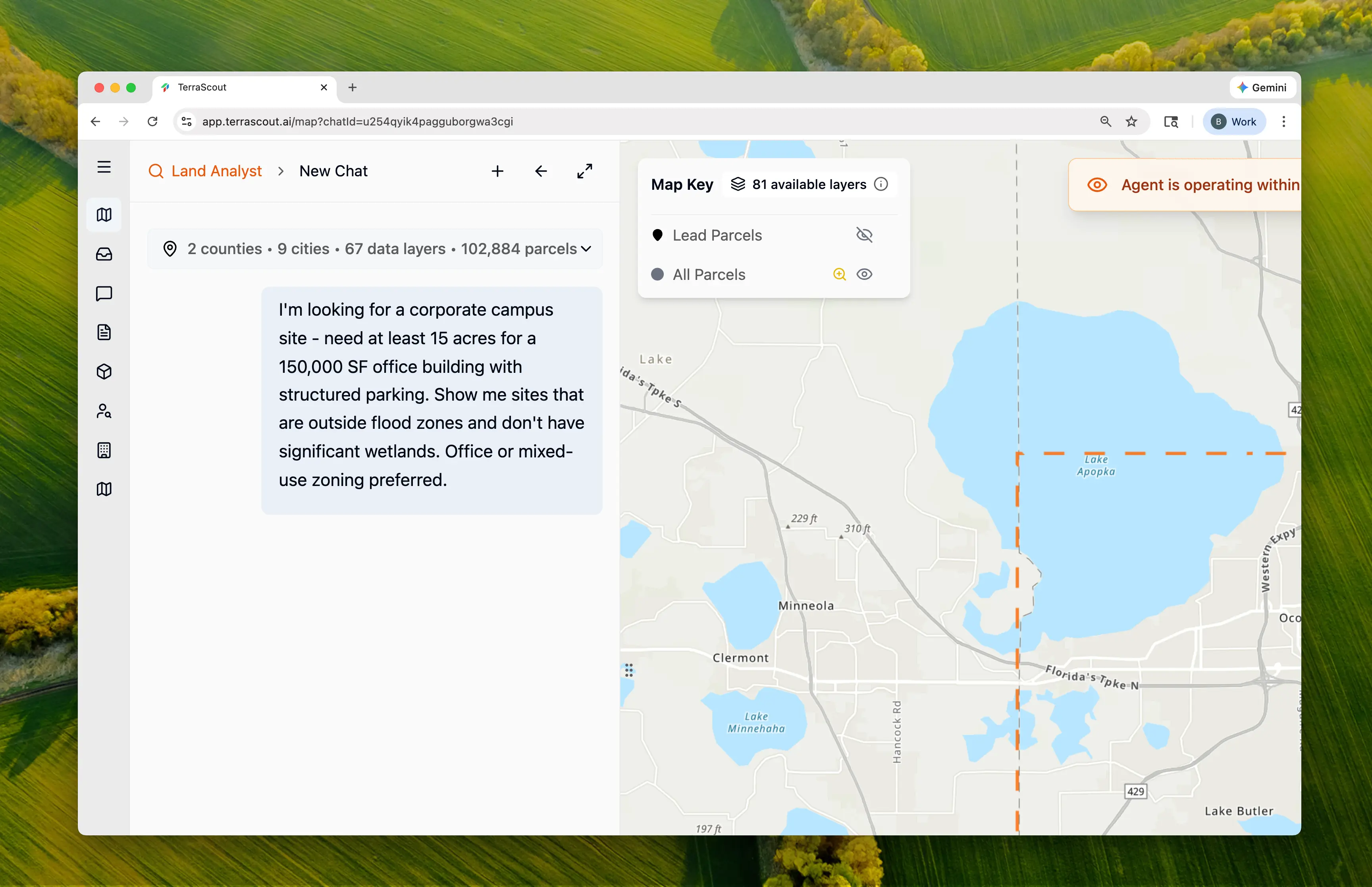
I’m looking for a corporate campus site - need at least 15 acres for a 150,000 SF office building with structured parking. Show me sites that are outside flood zones and don’t have significant wetlands. Office or mixed-use zoning preferred.This single question triggers research across multiple data layers:
- Parcel data (size filtering)
- Zoning codes (per-municipality research)
- FEMA flood hazard zones
- Wetland areas
Step 3: Watch the Research Happen
Ploti recognizes that your boundary spans 5 jurisdictions and researches each one separately—because different cities use different zoning codes. The agent:- Identified all municipalities in your boundary
- Searched each municipality’s code for office-permitted zones
- Found 532 parcels over 15 acres
- Cataloged FEMA flood hazard areas (A, AE, AH zones)
- Mapped 2,673 wetland areas
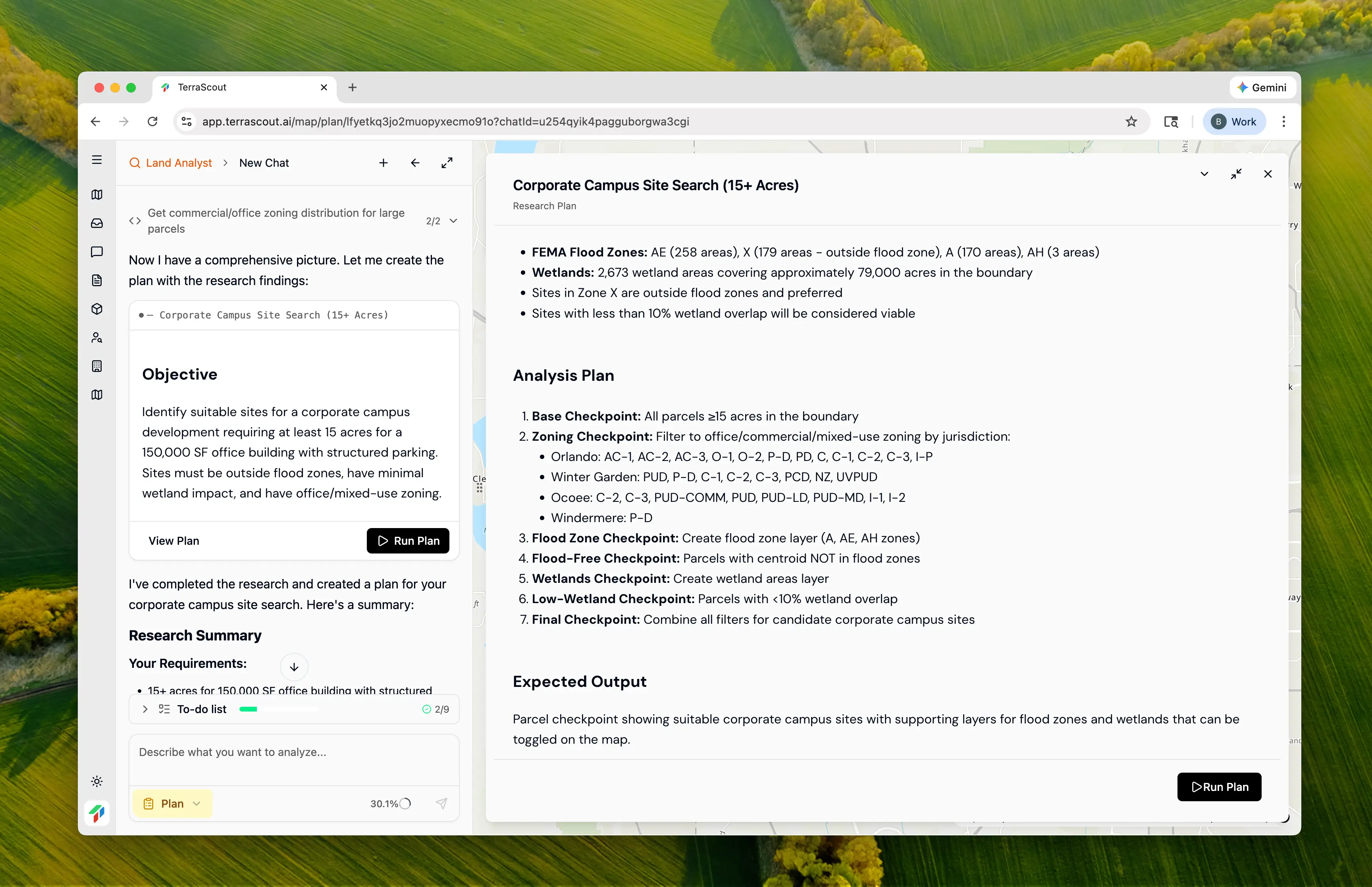
Step 4: Review the Plan
| Municipality | Permitted Zoning Codes | Parcels 15+ ac |
|---|---|---|
| Orlando | AC-1, AC-2, AC-3, O-1, O-2, P-D, C-1, C-2, C-3 | 77 |
| Winter Garden | PUD, P-D, C-1, C-2, C-3, PCD, NZ, UVPUD | 81 |
| Ocoee | C-2, C-3, PUD-COMM, PUD, I-1, I-2 | 44 |
| Windermere | P-D (Planned Development) | 30 |
- Orange County Code § 38-803 — Professional Office District (O-1)
- Orlando LDC FG-2B — Activity Center districts permitted uses
- Winter Garden Code Div. 10 — C-3 Professional Office District
- Ocoee LDC § 6-14 — Commercial Development Regulations
Step 5: Run the Analysis
Click Run Plan to execute. Ploti creates checkpoints at each filtering step:| Step | Checkpoint | Count | Filter Applied |
|---|---|---|---|
| 1 | Large Parcels (15+ acres) | 532 | Minimum size for 150,000 SF + parking |
| 2 | Office/Commercial Zoned | 226 | Per-municipality zoning codes |
| 3 | Outside Flood Zones | 156 | Centroid not in FEMA A/AE/AH zones |
| 4 | Final Candidates | 90 | Less than 10% wetland coverage |
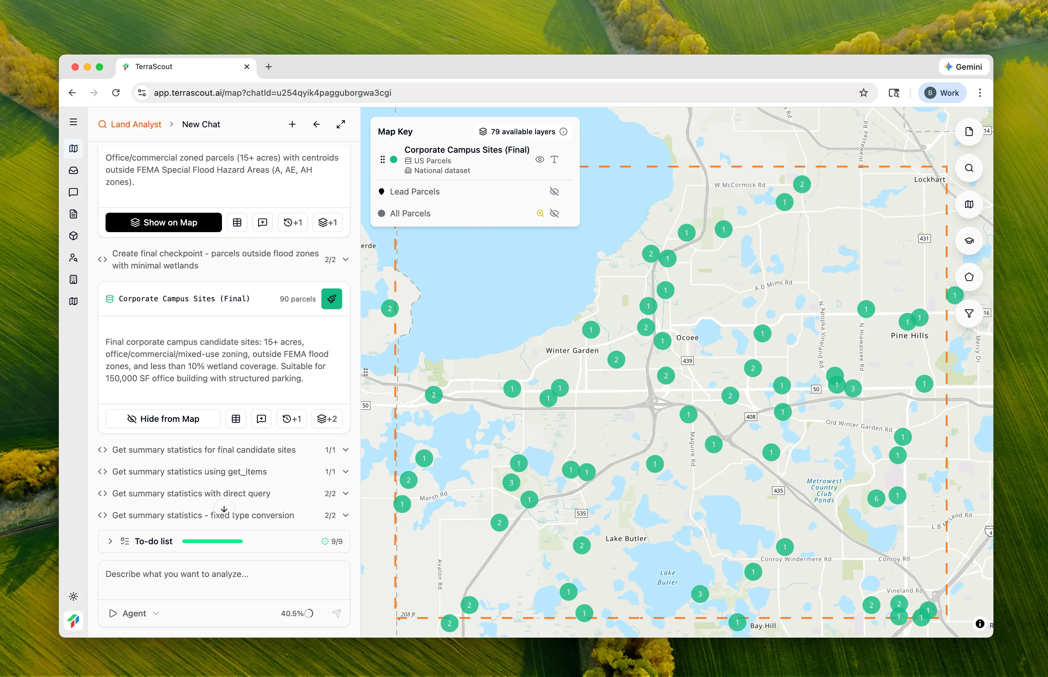
Step 6: Explore the Results
- 15+ acres
- Office/commercial/mixed-use zoning
- Outside FEMA flood hazard areas
- Less than 10% wetland coverage
| City | Parcels | Key Zoning Codes |
|---|---|---|
| Orlando | 30 | AC-2, P-D, AC-3/MA, O-2 |
| Winter Garden | 30 | PUD, NZ, P-D, C-2, PCD |
| Ocoee | 17 | C-2, PUD-COMM, C-3, I-1 |
| Windermere | 8 | P-D |
| Apopka | 3 | PUD-LD, PUD-MD |
| Montverde | 2 | PUD |
Step 7: Toggle Supporting Layers
The analysis created supporting checkpoints you can toggle on the map:- FEMA Flood Hazard Areas (431 zones) — See the flood risk areas that were avoided
- Wetland Areas (2,673 areas) — See the wetlands filtered for low-impact sites
Step 8: Examine Individual Sites
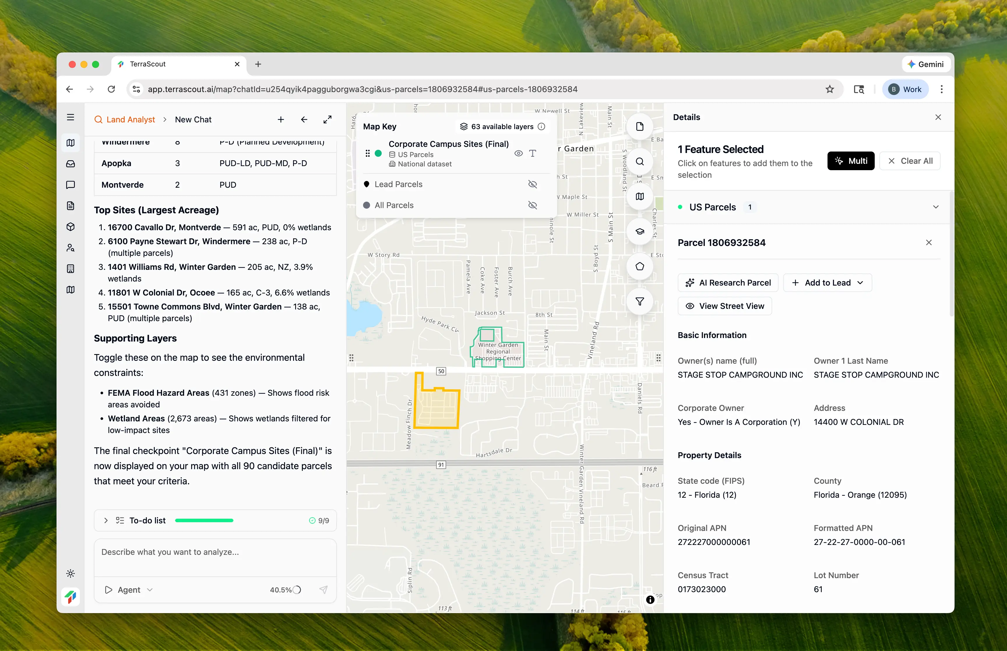
- Owner name and mailing address
- Exact acreage and dimensions
- Current zoning designation
- Assessed value and sale history
- Legal description
| Address | Acreage | Zoning | Wetland % |
|---|---|---|---|
| 16700 Cavallo Dr, Montverde | 591 ac | PUD | 0% |
| 6100 Payne Stewart Dr, Windermere | 238 ac | P-D | 0% |
| 1401 Williams Rd, Winter Garden | 205 ac | NZ | 3.9% |
| 11801 W Colonial Dr, Ocoee | 165 ac | C-3 | 6.6% |
| 15501 Towne Commons Blvd, Winter Garden | 138 ac | PUD | 0% |
Why This Matters
This analysis demonstrates multi-layer spatial intelligence:- Regulatory research — Automatically researched zoning codes across 5 different municipalities
- Environmental screening — Combined FEMA flood data with wetland analysis
- Progressive filtering — Showed exactly how each constraint narrowed results (532 → 226 → 156 → 90)
- Provenance tracking — Each checkpoint links to the data layers that contributed
- Verifiable findings — Ordinance citations link to actual municipal codes
- Identifying all jurisdictions in your search area
- Finding and reading zoning codes for 5+ municipalities
- Downloading FEMA flood maps and overlaying them
- Obtaining wetland data and calculating overlap percentages
- Cross-referencing everything in GIS software
Taking It Further
With 90 candidates, you might want to narrow down further. Just keep talking:Which of these are currently vacant land?Filter to shovel-ready sites without demolition.
Show me the ones closest to I-4Prioritize highway visibility and access.
Which sites have the lowest wetland percentage?Find the cleanest environmental profiles.
Sort by acreage and show the top 10 with owner informationGet contact details for outreach. Each refinement builds on the work already done—the agent remembers the zoning research and environmental screening.
Tips
- Parking ratios matter — Office typically requires 4 spaces per 1,000 SF; at 150,000 SF that’s 600 spaces requiring ~5 acres of surface parking or structured alternatives
- PUD zones require verification — Planned Unit Developments have site-specific approvals; check the recorded development order for permitted uses
- Wetland mitigation is expensive — Sites with even 5-10% wetland coverage may require permits and mitigation; prioritize 0% where possible
- Check height limits — Multi-story office may be restricted in some zones; verify with the planning department
- Activity Centers are prime locations — Orlando’s AC districts are specifically designed for employment centers and mixed-use development
Other Example Prompts
Medical Office Near Hospitals
Find parcels 2-5 acres within half a mile of hospitals, zoned commercial or office, with water and sewer accessMedical office clusters near hospitals for physician convenience.
Transit-Oriented Office
Find office-zoned parcels within a quarter mile of transit stations—I want to know about parking reductions available near transitTOD sites often qualify for reduced parking requirements.
Redevelopment Opportunities
Find parcels in commercial zones that are currently developed with low-value improvements, between 2-10 acres, in community redevelopment areasIdentify underutilized sites ripe for redevelopment.
Build-to-Suit Sites
What are the setback, height, and FAR requirements for office development in Orlando’s AC-2 district?Get development standards without searching through codes.