“This is the thing we have been wanting: a way to get the exact datasets we need around the decisions we make every week.”
- Manager at a home builder
Tell Ploti what dataset your business needs. AI agents find the sources, collect the data, organize it, and keep expanding it while you sleep.
Data agent
Custom request
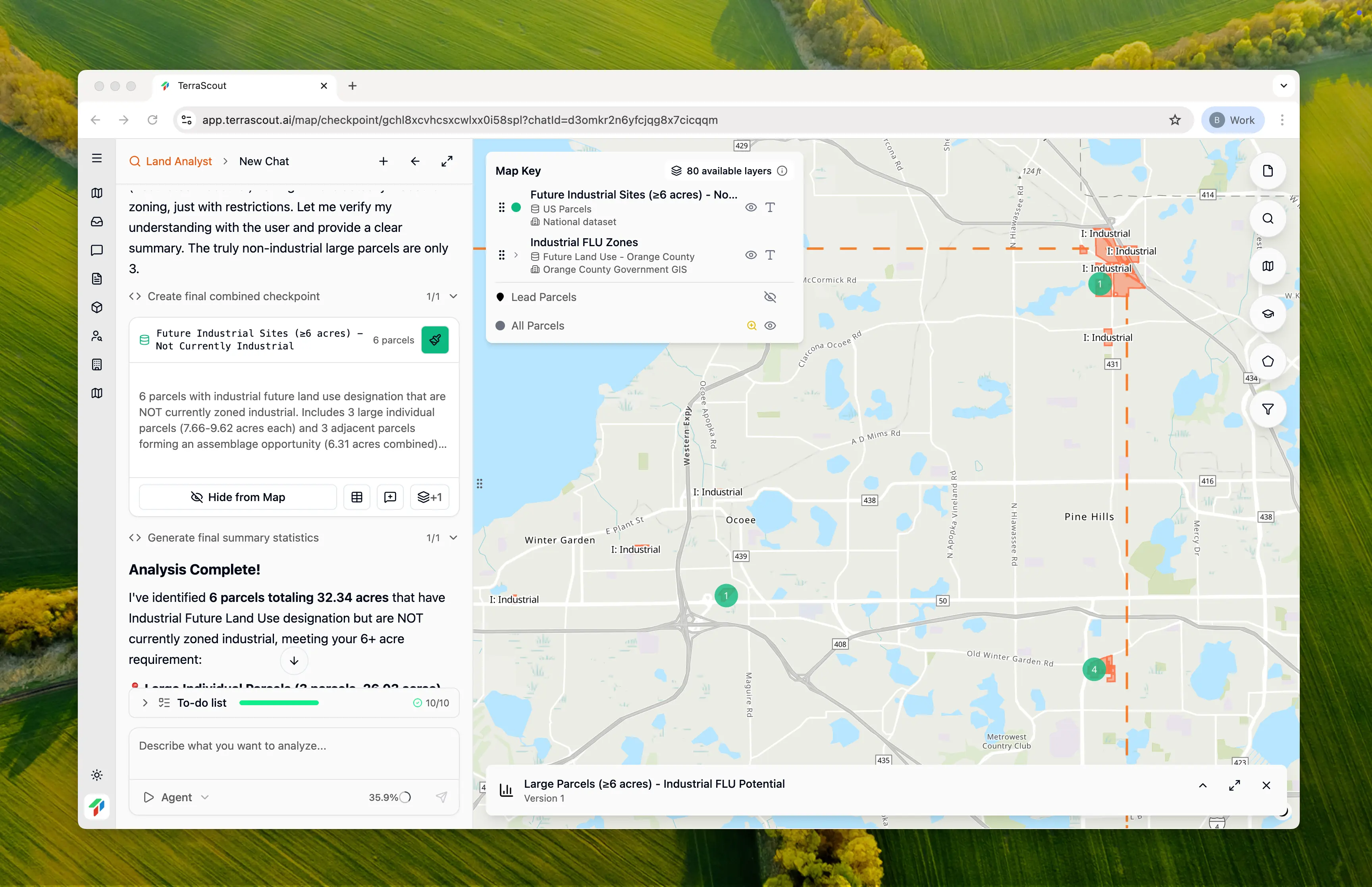
Find impact fee schedules for these counties.
1,392
custom datasets
54,827
questions answered
239
AI agents running right now
What teams are saying
“This is the thing we have been wanting: a way to get the exact datasets we need around the decisions we make every week.”
- Manager at a home builder
“This helps us stop bouncing between tools. The data, workflows, and answers finally live in one place.”
- Director at a land team
“This helps us see CRE lending opportunities before anyone else. We can watch owners, parcels, permits, and market signals in one system.”
- CRE lending lead at a bank
A new category of software
Ploti turns fragmented geospatial sources into dedicated AI agents that scrape, monitor, and expand the data layer your business runs on.
Plans start at $50/month.
Data sources
County GIS
Parcels, zoning, overlays
Public portals
Permits, agendas, records
Owner data
Mailing, entity, transaction history
Local rules
Ordinances, fees, constraints
Ploti harness
Sources into live datasets.
What your team gets
Custom workflows
Built around your decisions
Live dashboards
For the markets you track
Front-end agent
Answers across every dataset
How it works
Simply tell Ploti what counties you work in, and it starts pulling the data your team needs.
01 / Coverage
01 / Coverage
Pick the places your team cares about. Ploti builds your workspace around that coverage.
Sign up is easy. Plans start at $50/month with a free trial.
Start free trialSetup
02 / Collection
02 / Collection
Agents find the public records, map layers, ordinances, and local sources for those counties.
Source discovery
County records
Portal extraction
Public systems
Ordinance source sync
Municode + county code
03 / Requests
03 / Requests
If the data is missing, ask for it. Ploti assigns an agent to find and maintain it.
User request
Dedicated agent created
04 / Answers
04 / Answers
Ask questions across the data. Compare sites, find constraints, and decide what to do next.
Get full access to the front-end agent. Pay only for what you use, starting at $50/month.
Start free trialAsk across the datasets in your workspace.
In Action
Watch the product in action and see how Ploti turns fragmented local data into one workflow you can actually use.
Potential unlocks
Your team requests the datasets, workflows, and answers that matter to your decisions. Ploti turns them into the system your business runs on.
Land OS
Find parcels, owners, zoning constraints, and entitlement signals for acquisition decisions.
Homebuilder OS
Source lots, track growth corridors, and understand the local constraints that affect yield.
Data Center OS
Find large-scale sites with power, fiber, water, zoning, environmental, and ownership context.
Renewables OS
Find viable sites with transmission, ownership, slope, wetlands, zoning, and permitting context.
Retail OS
Combine POI, traffic, parcels, ownership, zoning, permits, and competitor signals.
Logistics OS
Evaluate sites near highways, rail, ports, utilities, zoning, and owners.
Cell Tower OS
Evaluate potential tower sites with ownership, zoning, coverage, utilities, and permitting data.
Billboard OS
Identify viable sign locations with parcel, roadway, zoning, ownership, and visibility context.
Bank OS
Monitor collateral, property risk, ownership changes, and local market signals across loan portfolios.
Simple Pricing
Full access to every feature. Credits shared across your entire team. Scale as you grow.
For individuals and small teams
For teams with heavy usage
Need more credits? Purchase additional credits anytime. Only pay for what you use.
Once the data is in Ploti, your team can ask across all of it. Compare sites, explain constraints, and decide what to do next.