Ask Ploti’s map agent about the data in your coverage areas, and get maps, filters, snapshots, ordinance answers and exports back
The map agent is the AI assistant built into the Ploti app. You ask it questions in a chat beside a map. It reads the official records in your coverage areas (the counties your plan covers), highlights matching parcels on the map, answers zoning and ordinance questions from the local code, and saves results you can download. Every answer names its source.To use it, open Map in the sidebar, or open a result from a finished research request, and ask in the chat panel. The chat header calls it the General Agent.Use the map agent when the data is there and you want to explore it, follow up on a result, or refine it. Use a research request when the answer needs data Ploti may not have yet, or a longer run you can walk away from.
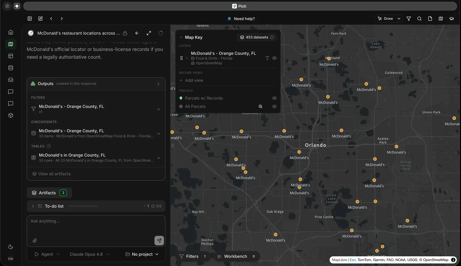
A completed research result mapped across Orange County with its outputs and map key available for inspection.
The agent searches the layers, tables and documents in your coverage areas
and reads them in full, by place, wherever the map is looking.
Maps and filters
A filter draws a layer with conditions, such as parcels over 20 acres owned
by an LLC, and stays live as the data updates.
Snapshots
A snapshot saves a fixed set of places, such as your shortlist, as a map
layer and a table you can come back to.
Ordinances and documents
Ask what a zoning code allows, or what a plan or meeting record says. The
agent cites the section it read.
Analysis
Rankings, comparisons, statistics and spatial joins, run on Ploti’s servers.
Exports and files
Export a snapshot’s or table’s visible rows as CSV, or ask the agent to save
a file, such as a CSV, a PDF or an image.
The agent can also search the web for context, read files you attach with Attach files, and start a research request from the chat when the data you need isn’t in Ploti yet.
Name the place, the criteria that matter, and what a useful answer looks like:
Compare these three parcels for a 60,000 square foot industrial building.Account for access, flood exposure, nearby utilities and zoning. Return acomparison table and call out what still needs verification.
Follow-ups can refer to what’s on the map:
Tighten this to parcels with at least 10 usable acres.
Why were these properties excluded?
What does the city's code require for parking at a self-storage facility here?
Pan and zoom, search for a place, and select any feature to see its attributes. The map key lists what is drawn and lets you show, hide and restyle each layer. Some layers, such as parcels, appear only once the map is zoomed in close enough; the agent reads them by place either way.
The map agent uses credits, Ploti’s unit for paid work, as it works. Everyone in your workspace (your team’s Ploti account) shares one balance. See Coverage areas and pricing.
Public records can be incomplete or out of date. Confirm material facts with
the source the agent cites, or with the relevant agency, before you rely on
them.
{"docsConfig":{"theme":"mint","$schema":"https://mintlify.com/docs.json","name":"Ploti","colors":{"primary":"#3bcb65","light":"#4fd676","dark":"#2eb354"},"logo":{"light":"https://mintcdn.com/terrascout/kNNmonUEy_ypBgxH/logo/light.svg?fit=max\u0026auto=format\u0026n=kNNmonUEy_ypBgxH\u0026q=85\u0026s=b08c70c377f893e7ecdb3ae552679143","dark":"https://mintcdn.com/terrascout/iWEY5yUmVnBadbAB/logo/dark.svg?fit=max\u0026auto=format\u0026n=iWEY5yUmVnBadbAB\u0026q=85\u0026s=5725fd33b41a96eb730a44148d93be18","href":"https://ploti.ai"},"favicon":"https://mintcdn.com/terrascout/kNNmonUEy_ypBgxH/favicon.svg?fit=max\u0026auto=format\u0026n=kNNmonUEy_ypBgxH\u0026q=85\u0026s=19edf9b52c65e35027256caca12adcde","api":{"playground":{"display":"none"}},"appearance":{"default":"dark","strict":true},"background":{"color":{"dark":"#08090a"}},"navbar":{"links":[{"href":"mailto:support@ploti.ai","label":"Support"}],"primary":{"type":"button","label":"Open App","href":"https://app.ploti.ai"}},"footer":{"socials":{"linkedin":"https://linkedin.com/company/ploti"}},"styling":{"latex":true},"navigation":{"global":{"anchors":[{"anchor":"Dashboard","icon":"grid-2","href":"https://app.ploti.ai"},{"anchor":"Support","icon":"envelope","href":"mailto:support@ploti.ai"}]},"pages":[]}},"deployment":{"deploymentMetadataValue":{"subdomain":"terrascout","hasAudioNarration":false,"actualSubdomain":"terrascout","customDomains":["ploti.ai"],"gitSource":{"type":"github","owner":"terrascout-ai","repo":"terrascout","deployBranch":"main","contentDirectory":"packages/www/apps/docs","isPrivate":true,"mountPath":"","label":""},"entitlements":{},"buildId":"6af639b6be94858690cda26b","clientVersion":"0.0.4117","searchFilterCounts":[{"language":"default","tag":"Developers","count":43},{"language":"default","tag":"Data Feeds API reference","count":25},{"language":"default","tag":"AI agents","count":20},{"language":"default","tag":"Own the data","count":10},{"language":"default","tag":"Start here","count":8},{"language":"default","tag":"API Reference","count":8},{"language":"default","tag":"Ploti app","count":7},{"language":"default","tag":"Subscriptions","count":7},{"language":"default","tag":"Query Ploti directly","count":6},{"language":"default","tag":"Overview","count":6}]},"assistantConfig":{"enableAskAiButton":false,"enableStarterQuestions":false,"enableAskAiSearchBar":true},"basePath":"/docs","hasChatPermissions":false,"hasWebMcpPermissions":false,"toggles":[{"name":"kill-isr","enabled":true,"variant":{"name":"disabled","enabled":false,"feature_enabled":true},"impressionData":false},{"name":"custom-rbac-roles","enabled":true,"variant":{"name":"disabled","enabled":false,"feature_enabled":true},"impressionData":false},{"name":"agent-mintlify-slack","enabled":true,"variant":{"name":"disabled","enabled":false,"feature_enabled":true},"impressionData":false},{"name":"agent-integrations-settings","enabled":true,"variant":{"name":"disabled","enabled":false,"feature_enabled":true},"impressionData":false},{"name":"rbac-expansion","enabled":true,"variant":{"name":"disabled","enabled":false,"feature_enabled":true},"impressionData":false},{"name":"automations-pr-grouping","enabled":true,"variant":{"name":"disabled","enabled":false,"feature_enabled":true},"impressionData":false},{"name":"custom-prefix","enabled":true,"variant":{"name":"disabled","enabled":false,"feature_enabled":true},"impressionData":false},{"name":"analytics-v7","enabled":true,"variant":{"name":"disabled","enabled":false,"feature_enabled":true},"impressionData":false},{"name":"user-flows-analytics","enabled":true,"variant":{"name":"disabled","enabled":false,"feature_enabled":true},"impressionData":false},{"name":"no-publish-flow","enabled":true,"variant":{"name":"disabled","enabled":false,"feature_enabled":true},"impressionData":false},{"name":"workos-onboarding","enabled":true,"variant":{"name":"disabled","enabled":false,"feature_enabled":true},"impressionData":false},{"name":"snapshot-serving-live","enabled":true,"variant":{"name":"disabled","enabled":false,"feature_enabled":true},"impressionData":false},{"name":"stripTemperatureMiddleware","enabled":true,"variant":{"name":"disabled","enabled":false,"feature_enabled":true},"impressionData":false},{"name":"support-platform-pylon-zendesk","enabled":true,"variant":{"name":"disabled","enabled":false,"feature_enabled":true},"impressionData":false},{"name":"snapshot-serving","enabled":true,"variant":{"name":"disabled","enabled":false,"feature_enabled":true},"impressionData":false},{"name":"instant-rollback","enabled":true,"variant":{"name":"disabled","enabled":false,"feature_enabled":true},"impressionData":false},{"name":"granular-notifications-server","enabled":true,"variant":{"name":"disabled","enabled":false,"feature_enabled":true},"impressionData":false},{"name":"granular-notifications","enabled":true,"variant":{"name":"disabled","enabled":false,"feature_enabled":true},"impressionData":false},{"name":"automations-fable","enabled":true,"variant":{"name":"disabled","enabled":false,"feature_enabled":true},"impressionData":false},{"name":"fixed-ai-action-pricing","enabled":true,"variant":{"name":"disabled","enabled":false,"feature_enabled":true},"impressionData":false},{"name":"automation-resolve-merge-conflict","enabled":true,"variant":{"name":"disabled","enabled":false,"feature_enabled":true},"impressionData":false},{"name":"scoped-publishing","enabled":true,"variant":{"name":"disabled","enabled":false,"feature_enabled":true},"impressionData":false},{"name":"mintql","enabled":true,"variant":{"name":"disabled","enabled":false,"feature_enabled":true},"impressionData":false},{"name":"page-level-analytics","enabled":true,"variant":{"name":"disabled","enabled":false,"feature_enabled":true},"impressionData":false},{"name":"editor-version-history-v2","enabled":true,"variant":{"name":"disabled","enabled":false,"feature_enabled":true},"impressionData":false},{"name":"billing-page-v2","enabled":true,"variant":{"name":"disabled","enabled":false,"feature_enabled":true},"impressionData":false},{"name":"full-page-search","enabled":true,"variant":{"name":"disabled","enabled":false,"feature_enabled":true},"impressionData":false},{"name":"workspace-projects","enabled":true,"variant":{"name":"disabled","enabled":false,"feature_enabled":true},"impressionData":false},{"name":"assistant-v5","enabled":true,"variant":{"name":"disabled","enabled":false,"feature_enabled":true},"impressionData":false},{"name":"fork-pr-previews","enabled":true,"variant":{"name":"disabled","enabled":false,"feature_enabled":true},"impressionData":false},{"name":"revalidation-jwt","enabled":true,"variant":{"name":"disabled","enabled":false,"feature_enabled":true},"impressionData":false},{"name":"workos-sso-scim","enabled":true,"variant":{"name":"disabled","enabled":false,"feature_enabled":true},"impressionData":false},{"name":"hobby-abuse-scan","enabled":true,"variant":{"name":"disabled","enabled":false,"feature_enabled":true},"impressionData":false},{"name":"dashboard-inbox","enabled":true,"variant":{"name":"disabled","enabled":false,"feature_enabled":true},"impressionData":false},{"name":"workos-signup","enabled":true,"variant":{"name":"disabled","enabled":false,"feature_enabled":true},"impressionData":false},{"name":"turbopuffer-dual-write","enabled":true,"variant":{"name":"disabled","enabled":false,"feature_enabled":true},"impressionData":false},{"name":"workos-enabled","enabled":true,"variant":{"name":"disabled","enabled":false,"feature_enabled":true},"impressionData":false},{"name":"approve-review-flow","enabled":true,"variant":{"name":"disabled","enabled":false,"feature_enabled":true},"impressionData":false},{"name":"editor-metadata","enabled":true,"variant":{"name":"disabled","enabled":false,"feature_enabled":true},"impressionData":false},{"name":"sso-setup-deadline-banner","enabled":true,"variant":{"name":"disabled","enabled":false,"feature_enabled":true},"impressionData":false},{"name":"turbopuffer-serve","enabled":true,"variant":{"name":"disabled","enabled":false,"feature_enabled":true},"impressionData":false},{"name":"live-agents","enabled":true,"variant":{"name":"disabled","enabled":false,"feature_enabled":true},"impressionData":false},{"name":"llms-txt-v2","enabled":true,"variant":{"name":"disabled","enabled":false,"feature_enabled":true},"impressionData":false}],"googleFontsInlined":false},"customCss":[{"filePath":"style.css","content":"#navbar img{height:20px!important;width:auto!important}#navbar a[href=\"https://ploti.ai\"] img{height:20px!important;width:auto!important}.mcp-image-placeholder,.docs-image-placeholder{align-items:center;aspect-ratio:16 / 9;background:linear-gradient(135deg, rgb(59 203 101 / 10%), transparent 55%),\n repeating-linear-gradient(\n -45deg,\n rgb(148 163 184 / 8%),\n rgb(148 163 184 / 8%) 10px,\n transparent 10px,\n transparent 20px\n );border:1px dashed rgb(148 163 184 / 70%);border-radius:0.75rem;color:rgb(100 116 139);display:flex;flex-direction:column;gap:0.35rem;justify-content:center;min-height:15rem;padding:2rem;text-align:center}.mcp-image-placeholder strong,.docs-image-placeholder strong{color:rgb(51 65 85);font-size:0.95rem}.mcp-image-placeholder span,.docs-image-placeholder span{font-size:0.8rem;line-height:1.4;max-width:34rem}html.dark .mcp-image-placeholder,html.dark .docs-image-placeholder{color:rgb(148 163 184)}html.dark .mcp-image-placeholder strong,html.dark .docs-image-placeholder strong{color:rgb(226 232 240)}"}],"page":{"pagePath":"research/map-agent","slug":"/research/map-agent","pageMetadata":{"title":"The map agent","description":"Ask Ploti's map agent about the data in your coverage areas, and get maps, filters, snapshots, ordinance answers and exports back","href":"/research/map-agent"},"description":{"compiledSource":"\"use strict\";\nconst {jsx: _jsx} = arguments[0];\nconst {useMDXComponents: _provideComponents} = arguments[0];\nfunction _createMdxContent(props) {\n const _components = {\n p: \"p\",\n ..._provideComponents(),\n ...props.components\n };\n return _jsx(_components.p, {\n children: \"Ask Ploti’s map agent about the data in your coverage areas, and get maps, filters, snapshots, ordinance answers and exports back\"\n });\n}\nfunction MDXContent(props = {}) {\n const {wrapper: MDXLayout} = {\n ..._provideComponents(),\n ...props.components\n };\n return MDXLayout ? _jsx(MDXLayout, {\n ...props,\n children: _jsx(_createMdxContent, {\n ...props\n })\n }) : _createMdxContent(props);\n}\nreturn {\n default: MDXContent\n};\n","frontmatter":{},"scope":{}},"pageType":"default","mdx":{"mdxSource":{"compiledSource":"\"use strict\";const{Fragment:_Fragment,jsx:_jsx,jsxs:_jsxs}=arguments[0];const{useMDXComponents:_provideComponents}=arguments[0];function _createMdxContent(props){const _components={a:`a`,code:`code`,p:`p`,pre:`pre`,span:`span`,strong:`strong`,..._provideComponents(),...props.components},{Card,CardGroup,CodeBlock,Frame,Heading,OptimizedImage,Warning}=_components;if(!Card)_missingMdxReference(`Card`,true);if(!CardGroup)_missingMdxReference(`CardGroup`,true);if(!CodeBlock)_missingMdxReference(`CodeBlock`,true);if(!Frame)_missingMdxReference(`Frame`,true);if(!Heading)_missingMdxReference(`Heading`,true);if(!OptimizedImage)_missingMdxReference(`OptimizedImage`,true);if(!Warning)_missingMdxReference(`Warning`,true);return _jsxs(_Fragment,{children:[_jsx(_components.p,{children:`The map agent is the AI assistant built into the Ploti app. You ask it questions in a chat beside a map. It reads the official records in your coverage areas (the counties your plan covers), highlights matching parcels on the map, answers zoning and ordinance questions from the local code, and saves results you can download. Every answer names its source.`}),`\n`,_jsxs(_components.p,{children:[`To use it, open `,_jsx(_components.strong,{children:`Map`}),` in the sidebar, or open a result from a finished research request, and ask in the chat panel. The chat header calls it the `,_jsx(_components.strong,{children:`General Agent`}),`.`]}),`\n`,_jsxs(_components.p,{children:[`Use the map agent when the data is there and you want to explore it, follow up on a result, or refine it. Use a `,_jsx(_components.a,{href:`/research/overview`,children:`research request`}),` when the answer needs data Ploti may not have yet, or a longer run you can walk away from.`]}),`\n`,_jsx(Frame,{caption:`A completed research result mapped across Orange County with its outputs and map key available for inspection.`,children:_jsx(OptimizedImage,{src:`https://cdn.ploti.ai/static/docs/ploti-app/ca070795c4c17e5706d558014e775a3e9cfa16362e7d11175d974dad55d55c9e/result-on-map.webp`,alt:`Ploti map showing McDonald's locations across the Orlando area, with the research outputs on the left and the result layer in the Map Key.`})}),`\n`,_jsx(Heading,{level:`2`,id:`what-you-can-ask-for`,children:`What you can ask for`}),`\n`,_jsxs(CardGroup,{cols:2,children:[_jsx(Card,{title:`Find and read data`,icon:`magnifying-glass`,children:_jsx(_components.p,{children:`The agent searches the layers, tables and documents in your coverage areas\nand reads them in full, by place, wherever the map is looking.`})}),_jsx(Card,{title:`Maps and filters`,icon:`filter`,children:_jsx(_components.p,{children:`A filter draws a layer with conditions, such as parcels over 20 acres owned\nby an LLC, and stays live as the data updates.`})}),_jsx(Card,{title:`Snapshots`,icon:`camera`,children:_jsx(_components.p,{children:`A snapshot saves a fixed set of places, such as your shortlist, as a map\nlayer and a table you can come back to.`})}),_jsx(Card,{title:`Ordinances and documents`,icon:`book-open`,children:_jsx(_components.p,{children:`Ask what a zoning code allows, or what a plan or meeting record says. The\nagent cites the section it read.`})}),_jsx(Card,{title:`Analysis`,icon:`chart-line`,children:_jsx(_components.p,{children:`Rankings, comparisons, statistics and spatial joins, run on Ploti’s servers.`})}),_jsx(Card,{title:`Exports and files`,icon:`file-export`,children:_jsx(_components.p,{children:`Export a snapshot’s or table’s visible rows as CSV, or ask the agent to save\na file, such as a CSV, a PDF or an image.`})})]}),`\n`,_jsxs(_components.p,{children:[`The agent can also search the web for context, read files you attach with `,_jsx(_components.strong,{children:`Attach files`}),`, and start a research request from the chat when the data you need isn’t in Ploti yet.`]}),`\n`,_jsx(Heading,{level:`2`,id:`ask-well`,children:`Ask well`}),`\n`,_jsx(_components.p,{children:`Name the place, the criteria that matter, and what a useful answer looks like:`}),`\n`,_jsx(CodeBlock,{filename:``,numberOfLines:`4`,language:`text`,children:_jsx(_components.pre,{className:`shiki shiki-themes github-light-default dark-plus`,style:{backgroundColor:`#ffffff`,\"--shiki-dark-bg\":`#0B0C0E`,color:`#1f2328`,\"--shiki-dark\":`#D4D4D4`},language:`text`,children:_jsxs(_components.code,{language:`text`,numberOfLines:`4`,children:[_jsx(_components.span,{className:`line`,children:_jsx(_components.span,{children:`Compare these three parcels for a 60,000 square foot industrial building.`})}),`\n`,_jsx(_components.span,{className:`line`,children:_jsx(_components.span,{children:`Account for access, flood exposure, nearby utilities and zoning. Return a`})}),`\n`,_jsx(_components.span,{className:`line`,children:_jsx(_components.span,{children:`comparison table and call out what still needs verification.`})}),`\n`,_jsx(_components.span,{className:`line`,children:_jsx(_components.span,{})})]})})}),`\n`,_jsx(_components.p,{children:`Follow-ups can refer to what’s on the map:`}),`\n`,_jsx(CodeBlock,{filename:``,numberOfLines:`2`,language:`text`,children:_jsx(_components.pre,{className:`shiki shiki-themes github-light-default dark-plus`,style:{backgroundColor:`#ffffff`,\"--shiki-dark-bg\":`#0B0C0E`,color:`#1f2328`,\"--shiki-dark\":`#D4D4D4`},language:`text`,children:_jsxs(_components.code,{language:`text`,numberOfLines:`2`,children:[_jsx(_components.span,{className:`line`,children:_jsx(_components.span,{children:`Tighten this to parcels with at least 10 usable acres.`})}),`\n`,_jsx(_components.span,{className:`line`,children:_jsx(_components.span,{})})]})})}),`\n`,_jsx(CodeBlock,{filename:``,numberOfLines:`2`,language:`text`,children:_jsx(_components.pre,{className:`shiki shiki-themes github-light-default dark-plus`,style:{backgroundColor:`#ffffff`,\"--shiki-dark-bg\":`#0B0C0E`,color:`#1f2328`,\"--shiki-dark\":`#D4D4D4`},language:`text`,children:_jsxs(_components.code,{language:`text`,numberOfLines:`2`,children:[_jsx(_components.span,{className:`line`,children:_jsx(_components.span,{children:`Why were these properties excluded?`})}),`\n`,_jsx(_components.span,{className:`line`,children:_jsx(_components.span,{})})]})})}),`\n`,_jsx(CodeBlock,{filename:``,numberOfLines:`2`,language:`text`,children:_jsx(_components.pre,{className:`shiki shiki-themes github-light-default dark-plus`,style:{backgroundColor:`#ffffff`,\"--shiki-dark-bg\":`#0B0C0E`,color:`#1f2328`,\"--shiki-dark\":`#D4D4D4`},language:`text`,children:_jsxs(_components.code,{language:`text`,numberOfLines:`2`,children:[_jsx(_components.span,{className:`line`,children:_jsx(_components.span,{children:`What does the city's code require for parking at a self-storage facility here?`})}),`\n`,_jsx(_components.span,{className:`line`,children:_jsx(_components.span,{})})]})})}),`\n`,_jsx(Heading,{level:`2`,id:`inspect-the-result`,children:`Inspect the result`}),`\n`,_jsx(_components.p,{children:`Pan and zoom, search for a place, and select any feature to see its attributes. The map key lists what is drawn and lets you show, hide and restyle each layer. Some layers, such as parcels, appear only once the map is zoomed in close enough; the agent reads them by place either way.`}),`\n`,_jsx(Heading,{level:`2`,id:`credits`,children:`Credits`}),`\n`,_jsxs(_components.p,{children:[`The map agent uses credits, Ploti’s unit for paid work, as it works. Everyone in your workspace (your team’s Ploti account) shares one balance. See `,_jsx(_components.a,{href:`/getting-started/coverage-areas`,children:`Coverage areas and pricing`}),`.`]}),`\n`,_jsx(Warning,{children:_jsx(_components.p,{children:`Public records can be incomplete or out of date. Confirm material facts with\nthe source the agent cites, or with the relevant agency, before you rely on\nthem.`})})]})}function MDXContent(props={}){const{wrapper:MDXLayout}={..._provideComponents(),...props.components};return MDXLayout?_jsx(MDXLayout,{...props,children:_jsx(_createMdxContent,{...props})}):_createMdxContent(props)}return{default:MDXContent};function _missingMdxReference(id,component){throw new Error(`Expected `+(component?`component`:`object`)+\" `\"+id+\"` to be defined: you likely forgot to import, pass, or provide it.\")}","frontmatter":{},"scope":{"config":{},"pageMetadata":{"title":"The map agent","description":"Ask Ploti's map agent about the data in your coverage areas, and get maps, filters, snapshots, ordinance answers and exports back","href":"/research/map-agent"}}},"mdxSourceWithNoJs":null},"mdxExtracts":{"tableOfContents":[{"title":"What you can ask for","slug":"what-you-can-ask-for","depth":2,"children":[]},{"title":"Ask well","slug":"ask-well","depth":2,"children":[]},{"title":"Inspect the result","slug":"inspect-the-result","depth":2,"children":[]},{"title":"Credits","slug":"credits","depth":2,"children":[]}],"codeExamples":{}},"jsLinks":[],"subdomain":"terrascout","siteName":"Ploti","title":"The map agent - Ploti","navMaps":{"firstHrefInVersion":{},"firstHrefInLanguage":{}},"lastModified":"2026-11-11T16:04:53.426Z","originalFileLocation":"research/map-agent.mdx"},"headHtml":"\u003cscript data-mint-head>(function(){var d=document.documentElement,p=\"dark\";if(!p){try{p=localStorage.getItem(\"isDarkMode\")}catch(e){}if(p==='true')p='dark';else if(p==='false')p='light';if(p!=='light'\u0026\u0026p!=='dark'\u0026\u0026p!=='system')p=\"dark\"}var r=p==='system'?(matchMedia(\"(prefers-color-scheme: dark)\").matches?'dark':'light'):p;d.classList.remove(r==='dark'?'light':'dark');d.classList.add(r);d.setAttribute(\"data-theme-preference\",p)})();\u003c/script>\u003cmeta data-mint-head name=\"description\" content=\"Ask Ploti\u0026#x27;s map agent about the data in your coverage areas, and get maps, filters, snapshots, ordinance answers and exports back\">\u003cmeta data-mint-head name=\"application-name\" content=\"Ploti\">\u003cmeta data-mint-head name=\"generator\" content=\"Mintlify\">\u003clink data-mint-head rel=\"icon\" type=\"image/png\" sizes=\"192x192\" href=\"/docs/mintlify-assets/_mintlify/favicons/terrascout/IrGmES4fYp1Ma_BG/_generated/favicon/android-chrome-192x192.png\" media=\"(prefers-color-scheme: light)\">\u003clink data-mint-head rel=\"apple-touch-icon\" type=\"image/png\" sizes=\"180x180\" href=\"/docs/mintlify-assets/_mintlify/favicons/terrascout/IrGmES4fYp1Ma_BG/_generated/favicon/apple-touch-icon.png\">\u003clink data-mint-head rel=\"icon\" type=\"image/png\" sizes=\"16x16\" href=\"/docs/mintlify-assets/_mintlify/favicons/terrascout/IrGmES4fYp1Ma_BG/_generated/favicon/favicon-16x16.png\" media=\"(prefers-color-scheme: light)\">\u003clink data-mint-head rel=\"icon\" type=\"image/png\" sizes=\"32x32\" href=\"/docs/mintlify-assets/_mintlify/favicons/terrascout/IrGmES4fYp1Ma_BG/_generated/favicon/favicon-32x32.png\" media=\"(prefers-color-scheme: light)\">\u003clink data-mint-head rel=\"shortcut icon\" type=\"image/x-icon\" href=\"/docs/mintlify-assets/_mintlify/favicons/terrascout/IrGmES4fYp1Ma_BG/_generated/favicon/favicon.ico\" media=\"(prefers-color-scheme: light)\">\u003clink data-mint-head rel=\"icon\" type=\"image/png\" sizes=\"192x192\" href=\"/docs/mintlify-assets/_mintlify/favicons/terrascout/IrGmES4fYp1Ma_BG/_generated/favicon-dark/android-chrome-192x192.png\" media=\"(prefers-color-scheme: dark)\">\u003clink data-mint-head rel=\"icon\" type=\"image/png\" sizes=\"16x16\" href=\"/docs/mintlify-assets/_mintlify/favicons/terrascout/IrGmES4fYp1Ma_BG/_generated/favicon-dark/favicon-16x16.png\" media=\"(prefers-color-scheme: dark)\">\u003clink data-mint-head rel=\"icon\" type=\"image/png\" sizes=\"32x32\" href=\"/docs/mintlify-assets/_mintlify/favicons/terrascout/IrGmES4fYp1Ma_BG/_generated/favicon-dark/favicon-32x32.png\" media=\"(prefers-color-scheme: dark)\">\u003clink data-mint-head rel=\"shortcut icon\" type=\"image/x-icon\" href=\"/docs/mintlify-assets/_mintlify/favicons/terrascout/IrGmES4fYp1Ma_BG/_generated/favicon-dark/favicon.ico\" media=\"(prefers-color-scheme: dark)\">\u003cmeta data-mint-head property=\"og:title\" content=\"The map agent - Ploti\">\u003cmeta data-mint-head property=\"og:description\" content=\"Ask Ploti\u0026#x27;s map agent about the data in your coverage areas, and get maps, filters, snapshots, ordinance answers and exports back\">\u003cmeta data-mint-head property=\"og:site_name\" content=\"Ploti\">\u003cmeta data-mint-head property=\"og:url\" content=\"https://ploti.ai/docs/research/map-agent\">\u003cmeta data-mint-head property=\"og:type\" content=\"website\">\u003cmeta data-mint-head property=\"og:image\" content=\"https://terrascout.mintlify.site/docs/_mintlify/api/og/v2?division=The+map+agent\u0026amp;title=The+map+agent\u0026amp;description=Ask+Ploti%27s+map+agent+about+the+data+in+your+coverage+areas%2C+and+get+maps%2C+filters%2C+snapshots%2C+ordinance+answers+and+exports+back\u0026amp;theme=bb8899b90e67970f4579c4d1\u0026amp;signature=d5baaf76acab4958baf7d8e21190ded96cb12d62008b3c4d82ff580fcc22ee6c\">\u003cmeta data-mint-head property=\"og:image:width\" content=\"1200\">\u003cmeta data-mint-head property=\"og:image:height\" content=\"630\">\u003cmeta data-mint-head name=\"twitter:card\" content=\"summary_large_image\">\u003cmeta data-mint-head name=\"twitter:title\" content=\"The map agent - Ploti\">\u003cmeta data-mint-head name=\"twitter:description\" content=\"Ask Ploti\u0026#x27;s map agent about the data in your coverage areas, and get maps, filters, snapshots, ordinance answers and exports back\">\u003cmeta data-mint-head name=\"twitter:image\" content=\"https://terrascout.mintlify.site/docs/_mintlify/api/og/v2?division=The+map+agent\u0026amp;title=The+map+agent\u0026amp;description=Ask+Ploti%27s+map+agent+about+the+data+in+your+coverage+areas%2C+and+get+maps%2C+filters%2C+snapshots%2C+ordinance+answers+and+exports+back\u0026amp;theme=bb8899b90e67970f4579c4d1\u0026amp;signature=d5baaf76acab4958baf7d8e21190ded96cb12d62008b3c4d82ff580fcc22ee6c\">\u003cmeta data-mint-head name=\"twitter:image:width\" content=\"1200\">\u003cmeta data-mint-head name=\"twitter:image:height\" content=\"630\">\u003cmeta data-mint-head name=\"msapplication-config\" content=\"/docs/mintlify-assets/_mintlify/favicons/terrascout/IrGmES4fYp1Ma_BG/_generated/favicon/browserconfig.xml\">\u003cmeta data-mint-head name=\"apple-mobile-web-app-title\" content=\"Ploti\">\u003cmeta data-mint-head name=\"msapplication-TileColor\" content=\"#3bcb65\">\u003clink data-mint-head rel=\"canonical\" href=\"https://ploti.ai/docs/research/map-agent\">\u003clink data-mint-head rel=\"alternate\" type=\"application/xml\" href=\"/docs/sitemap.xml\">\u003clink data-mint-head rel=\"alternate\" type=\"text/markdown\" href=\"/docs/research/map-agent.md\">\u003cscript data-mint-head type=\"application/ld+json\">{\"@context\":\"https://schema.org\",\"@graph\":[{\"@type\":\"Organization\",\"@id\":\"https://ploti.ai/#organization\",\"name\":\"Ploti\",\"url\":\"https://ploti.ai\",\"logo\":{\"@type\":\"ImageObject\",\"url\":\"https://mintcdn.com/terrascout/kNNmonUEy_ypBgxH/logo/light.svg?fit=max\u0026auto=format\u0026n=kNNmonUEy_ypBgxH\u0026q=85\u0026s=b08c70c377f893e7ecdb3ae552679143\"}},{\"@type\":\"WebSite\",\"@id\":\"https://ploti.ai/docs#website\",\"name\":\"Ploti\",\"url\":\"https://ploti.ai/docs\",\"publisher\":{\"@id\":\"https://ploti.ai/#organization\"}},{\"@type\":\"WebPage\",\"@id\":\"https://ploti.ai/docs/research/map-agent#webpage\",\"url\":\"https://ploti.ai/docs/research/map-agent\",\"name\":\"The map agent\",\"description\":\"Ask Ploti's map agent about the data in your coverage areas, and get maps, filters, snapshots, ordinance answers and exports back\",\"dateModified\":\"2026-11-11T16:04:53.426Z\",\"isPartOf\":{\"@id\":\"https://ploti.ai/docs#website\"},\"breadcrumb\":{\"@id\":\"https://ploti.ai/docs/research/map-agent#breadcrumb\"}},{\"@type\":\"BreadcrumbList\",\"@id\":\"https://ploti.ai/docs/research/map-agent#breadcrumb\",\"itemListElement\":[{\"@type\":\"ListItem\",\"position\":1,\"name\":\"Ploti\",\"item\":\"https://ploti.ai/docs\"},{\"@type\":\"ListItem\",\"position\":2,\"name\":\"The map agent\",\"item\":\"https://ploti.ai/docs/research/map-agent\"}]},{\"@type\":[\"Article\",\"TechArticle\"],\"@id\":\"https://ploti.ai/docs/research/map-agent#article\",\"headline\":\"The map agent\",\"name\":\"The map agent\",\"description\":\"Ask Ploti's map agent about the data in your coverage areas, and get maps, filters, snapshots, ordinance answers and exports back\",\"url\":\"https://ploti.ai/docs/research/map-agent\",\"mainEntityOfPage\":{\"@id\":\"https://ploti.ai/docs/research/map-agent#webpage\"},\"dateModified\":\"2026-11-11T16:04:53.426Z\",\"publisher\":{\"@id\":\"https://ploti.ai/#organization\"},\"isPartOf\":{\"@id\":\"https://ploti.ai/docs#website\"}}]}\u003c/script>\u003cscript data-mint-head type=\"application/ld+json\">{\"@context\":\"https://schema.org\",\"@type\":\"WebSite\",\"name\":\"Ploti\",\"publisher\":{\"@type\":\"Organization\",\"name\":\"Ploti\"},\"provider\":{\"@type\":\"Organization\",\"name\":\"Mintlify\",\"url\":\"https://mintlify.com\"}}\u003c/script>","agentPointerHref":"/docs/research/map-agent.md","siteName":"Ploti","nav":{"global":{"anchors":[{"anchor":"Dashboard","icon":"grid-2","href":"https://app.ploti.ai"},{"anchor":"Support","icon":"envelope","href":"mailto:support@ploti.ai"}]},"tabs":[{"tab":"Overview","pages":[{"title":"Overview","href":""}]},{"tab":"Ploti app","groups":[{"group":"Start here","pages":[{"title":"Quickstart","href":"/getting-started/quickstart"}]},{"group":"Research requests","pages":[{"title":"How a research request works","href":"/research/overview"},{"title":"Write a research request","sidebarTitle":"Create a research request","href":"/research/creating-a-request"},{"title":"Example requests","description":"Research requests customers file, by kind of work, to copy and adapt to your own market","href":"/research/examples"}]},{"group":"The map agent","pages":[{"title":"The map agent","href":"/research/map-agent"}]},{"group":"Coverage areas","pages":[{"title":"Coverage areas and pricing","description":"How coverage areas work, what each county costs, the credits it includes, and how billing changes when you add or remove counties","href":"/getting-started/coverage-areas"},{"title":"Ordinance coverage","href":"/getting-started/ordinance-coverage"}]}]},{"tab":"AI agents","pages":[{"title":"AI agents","href":"/mcp/overview"}]},{"tab":"Developers","pages":[{"title":"Developers","href":"/developers/overview"}]}]},"basePath":"","title":"The map agent - Ploti","buildId":"dpl_AHzSCQPRq6mP9FZXEa5AbDZTffie","deploymentId":"dpl_AHzSCQPRq6mP9FZXEa5AbDZTffie","dynamics":["07c022d89b","a74be98ba7"],"chunks":["Frame-C3JmClLs.js","DynamicMarkdown-mBxoveKr.js","zoom-image-lightbox-BrVVh3El.js","lightbox-handle-r17bVUz3.js"]}