> ## Documentation Index
> Fetch the complete documentation index at: https://terrascout.ai/docs/llms.txt
> Use this file to discover all available pages before exploring further.
# Retail Void Analysis
> Find gaps in retail coverage by analyzing anchor tenant proximity and competitor locations
Retail void analysis identifies gaps where customer demand exists but supply doesn't. Ploti combines point-of-interest (POI) data with spatial analysis to find underserved locations—anchor tenants generating traffic without nearby competitors to capture it.
## The Opportunity
Retail site selection often follows anchor tenants:
* Grocery stores generate consistent daily traffic
* Customers make secondary stops (QSR, pharmacy, services)
* Being near anchors without competition is the sweet spot
The challenge: Manually mapping anchor locations, competitor locations, and available parcels across a metro area is time-intensive. Ploti automates this gap analysis.
## Walkthrough: Finding McDonald's Sites Near Underserved Publix Stores
Let's find potential McDonald's locations by identifying Publix grocery stores that don't have a McDonald's nearby. These represent gaps where grocery traffic could support a new QSR.
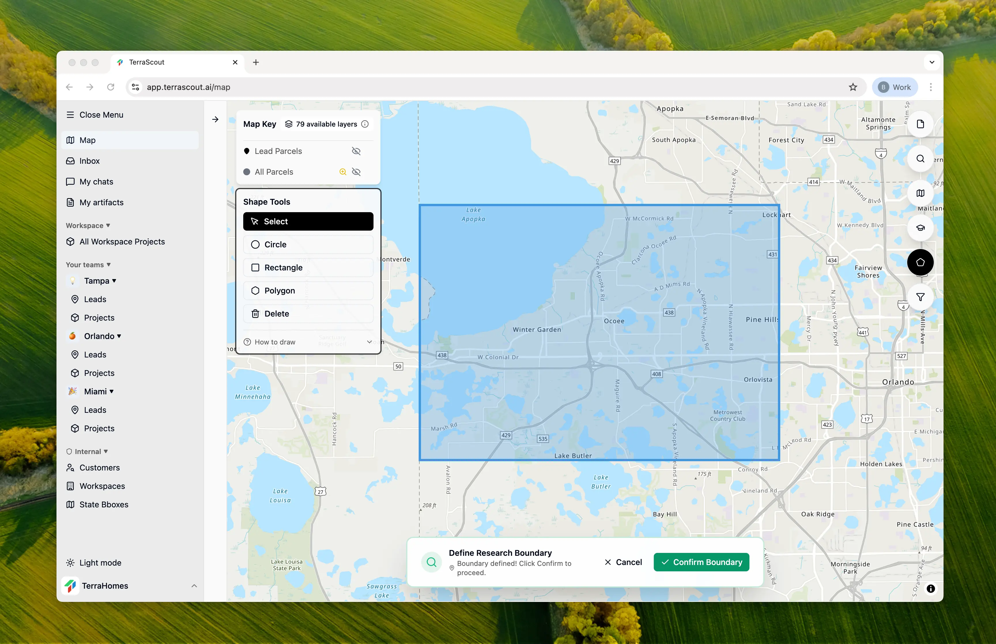
### Step 1: Select Your Search Area
Draw a boundary around your target market. In this example, we drew an area spanning Orlando, Winter Garden, Ocoee, and Windermere—capturing major grocery-anchored retail corridors.
 ### Step 2: Ask the Question
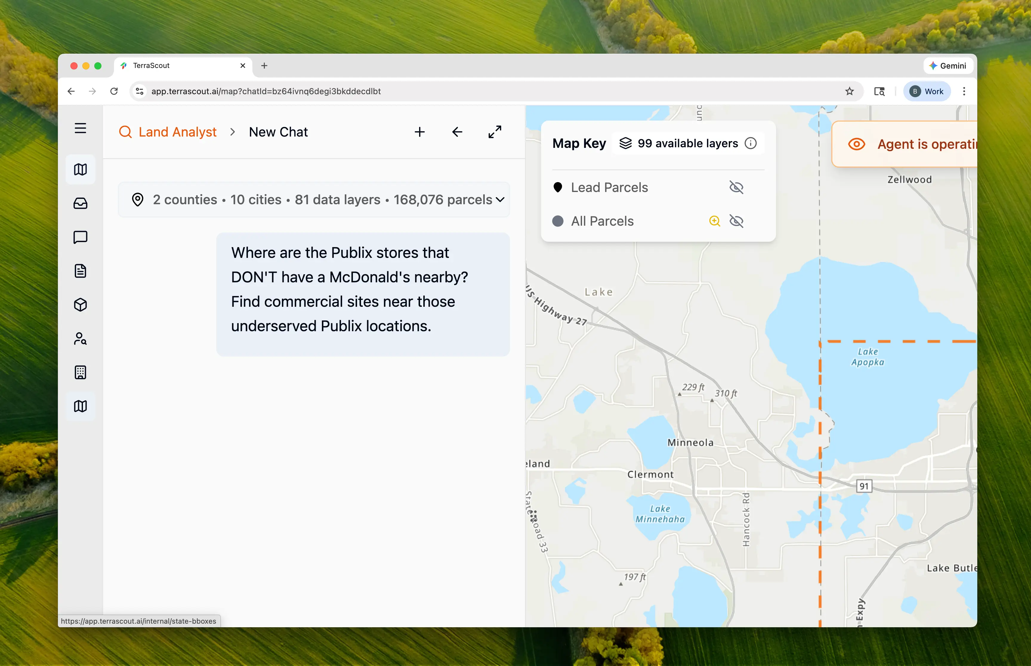 We asked:
> Where are the Publix stores that DON'T have a McDonald's nearby? Find commercial sites near those underserved Publix locations.
This frames the problem as gap analysis—find the anchors first, then the opportunities near them. Ploti:
* Discovers POI data for both brands
* Performs spatial exclusion analysis
* Identifies vacant commercial parcels
* Researches zoning for restaurant uses
### Step 3: Watch the Discovery
Ploti found POI data and performed the gap analysis:
**Locations Discovered:**
| Brand | Count | Source |
| ---------- | -------- | ------------ |
| Publix | Multiple | OSM POI data |
| McDonald's | 18 | OSM POI data |
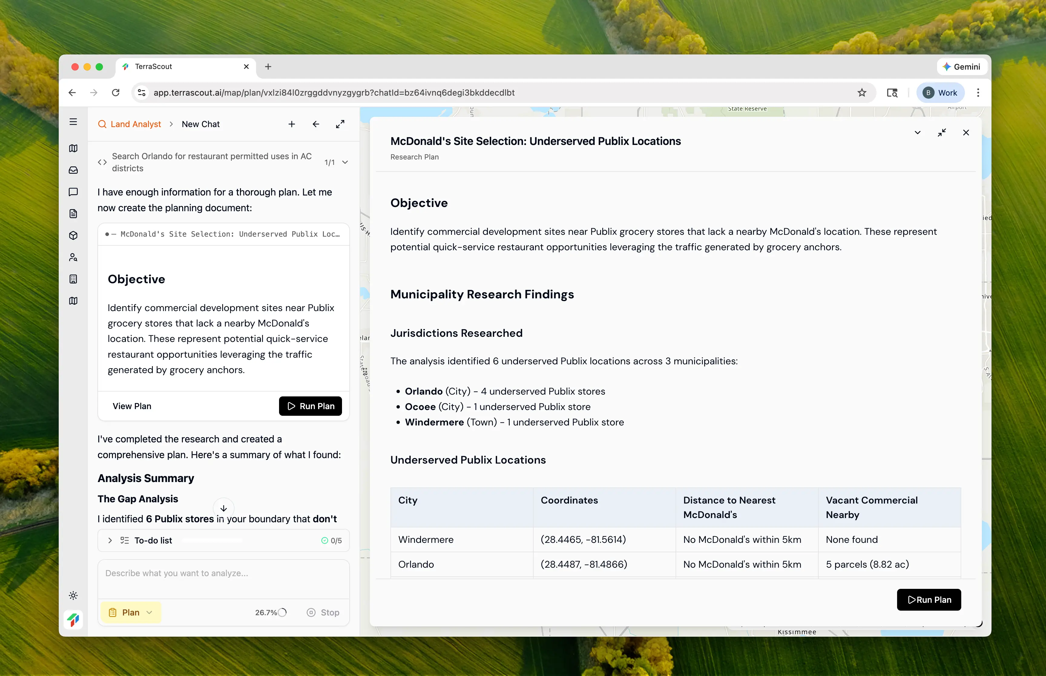
**Underserved Publix Locations Found:**
| City | Coordinates | Distance to Nearest McDonald's | Vacant Commercial Nearby |
| ---------- | ------------------- | ------------------------------ | ------------------------ |
| Windermere | (28.4465, -81.5614) | More than 5km | None found |
| Orlando | (28.4487, -81.4866) | More than 5km | 5 parcels (8.82 ac) |
| Orlando | (28.4908, -81.5105) | More than 5km | None found |
| Orlando | (28.5730, -81.4046) | 1.49 mi | 6 parcels (13.62 ac) |
| Ocoee | (28.5322, -81.5397) | 1.40 mi | 4 parcels (8.50 ac) |
| Orlando | (28.4877, -81.4151) | 1.22 mi | 5 parcels (28.89 ac) |
**Key Finding:** 6 Publix stores have no McDonald's within 0.5 miles—these are underserved locations where grocery traffic isn't being captured by an existing McDonald's.
### Step 4: Review the Plan
We asked:
> Where are the Publix stores that DON'T have a McDonald's nearby? Find commercial sites near those underserved Publix locations.
This frames the problem as gap analysis—find the anchors first, then the opportunities near them. Ploti:
* Discovers POI data for both brands
* Performs spatial exclusion analysis
* Identifies vacant commercial parcels
* Researches zoning for restaurant uses
### Step 3: Watch the Discovery
Ploti found POI data and performed the gap analysis:
**Locations Discovered:**
| Brand | Count | Source |
| ---------- | -------- | ------------ |
| Publix | Multiple | OSM POI data |
| McDonald's | 18 | OSM POI data |
**Underserved Publix Locations Found:**
| City | Coordinates | Distance to Nearest McDonald's | Vacant Commercial Nearby |
| ---------- | ------------------- | ------------------------------ | ------------------------ |
| Windermere | (28.4465, -81.5614) | More than 5km | None found |
| Orlando | (28.4487, -81.4866) | More than 5km | 5 parcels (8.82 ac) |
| Orlando | (28.4908, -81.5105) | More than 5km | None found |
| Orlando | (28.5730, -81.4046) | 1.49 mi | 6 parcels (13.62 ac) |
| Ocoee | (28.5322, -81.5397) | 1.40 mi | 4 parcels (8.50 ac) |
| Orlando | (28.4877, -81.4151) | 1.22 mi | 5 parcels (28.89 ac) |
**Key Finding:** 6 Publix stores have no McDonald's within 0.5 miles—these are underserved locations where grocery traffic isn't being captured by an existing McDonald's.
### Step 4: Review the Plan
 Ploti's plan:
1. Create checkpoint for underserved Publix locations (6 stores)
2. Create checkpoint for all McDonald's (reference layer)
3. Find vacant commercial parcels in Orlando near underserved Publix
4. Find vacant commercial parcels in Ocoee near underserved Publix
5. Create combined checkpoint of all potential sites
**Ordinance Citations:**
* Orlando LDC Table FG-2A — Allowable uses in AC-N, AC-1, AC-2, AC-3 districts
* Sec. 58.341 — Activity Center Districts purpose and intent
* Orange County Sec. 38-851 — General Commercial Districts (C-1, C-2, C-3)
* Orange County Sec. 38-1552 — Fast food/restaurant permitted locations
* Ocoee § 5-3 — C-1, C-2, C-3, PUD-COMM district definitions
### Step 5: Run the Analysis
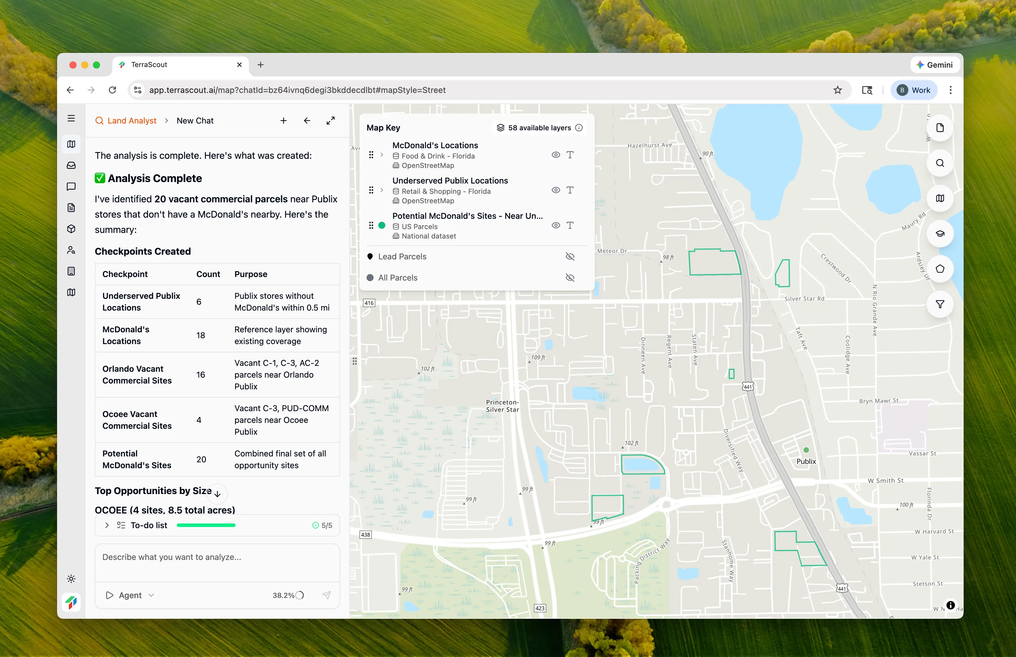
Click **Run Plan** to execute. Ploti creates multiple checkpoints:
| Checkpoint | Count | Description |
| ------------------------------ | ------ | ---------------------------------------------- |
| Underserved Publix Locations | 6 | Publix stores without McDonald's within 0.5 mi |
| McDonald's Locations | 18 | Reference layer showing existing coverage |
| Orlando Vacant Commercial | 16 | C-1, C-3, AC-2 parcels near Orlando Publix |
| Ocoee Vacant Commercial | 4 | C-3, PUD-COMM parcels near Ocoee Publix |
| **Potential McDonald's Sites** | **20** | Combined final set |
### Step 6: Review the Results
Ploti's plan:
1. Create checkpoint for underserved Publix locations (6 stores)
2. Create checkpoint for all McDonald's (reference layer)
3. Find vacant commercial parcels in Orlando near underserved Publix
4. Find vacant commercial parcels in Ocoee near underserved Publix
5. Create combined checkpoint of all potential sites
**Ordinance Citations:**
* Orlando LDC Table FG-2A — Allowable uses in AC-N, AC-1, AC-2, AC-3 districts
* Sec. 58.341 — Activity Center Districts purpose and intent
* Orange County Sec. 38-851 — General Commercial Districts (C-1, C-2, C-3)
* Orange County Sec. 38-1552 — Fast food/restaurant permitted locations
* Ocoee § 5-3 — C-1, C-2, C-3, PUD-COMM district definitions
### Step 5: Run the Analysis
Click **Run Plan** to execute. Ploti creates multiple checkpoints:
| Checkpoint | Count | Description |
| ------------------------------ | ------ | ---------------------------------------------- |
| Underserved Publix Locations | 6 | Publix stores without McDonald's within 0.5 mi |
| McDonald's Locations | 18 | Reference layer showing existing coverage |
| Orlando Vacant Commercial | 16 | C-1, C-3, AC-2 parcels near Orlando Publix |
| Ocoee Vacant Commercial | 4 | C-3, PUD-COMM parcels near Ocoee Publix |
| **Potential McDonald's Sites** | **20** | Combined final set |
### Step 6: Review the Results
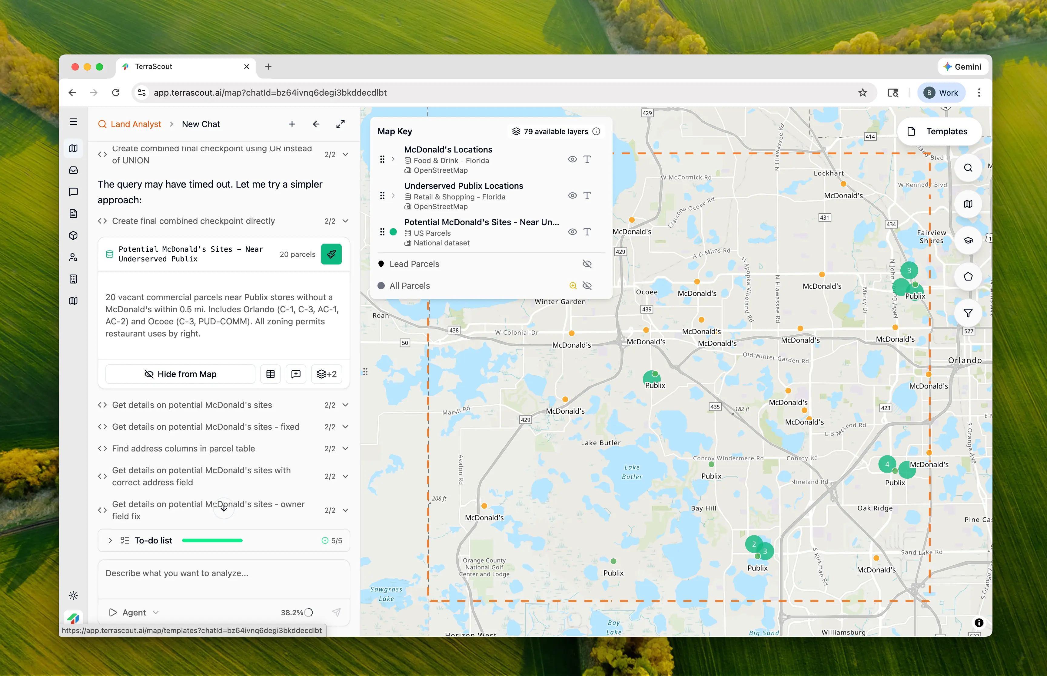 The map shows three layers working together:
* **Publix locations** — The underserved anchor tenants
* **McDonald's locations** — Existing coverage (to visualize the gaps)
* **Vacant commercial parcels** — Development opportunities
**20 potential sites** identified across Orlando and Ocoee with commercial zoning permitting restaurant uses.
### Step 7: Examine Specific Opportunities
The map shows three layers working together:
* **Publix locations** — The underserved anchor tenants
* **McDonald's locations** — Existing coverage (to visualize the gaps)
* **Vacant commercial parcels** — Development opportunities
**20 potential sites** identified across Orlando and Ocoee with commercial zoning permitting restaurant uses.
### Step 7: Examine Specific Opportunities
 Zooming into a specific area shows the spatial relationship:
* The Publix anchor generating traffic
* Nearby McDonald's locations (or lack thereof)
* Available commercial parcels for development
**Top Opportunities by Size:**
| Location | Acres | Zoning | Address/Area |
| -------- | ----- | -------- | --------------------------------- |
| Ocoee | 4.88 | PUD-COMM | 3010 Maguire Rd (Maguire Shoppes) |
| Orlando | 13.63 | C | Timarron Dr (Millennium Parc) |
| Orlando | 11.05 | C | S John Young Pkwy |
| Orlando | 4.50 | C-3 | 3100 N Orange Blossom Trl |
| Orlando | 4.36 | C-1 | Somerset Shores Ct (Dr Phillips) |
### Step 8: Understand the Zoning
Each municipality has different commercial zoning codes, but all identified parcels permit restaurant uses:
| Municipality | Commercial Codes | Restaurant Permitted |
| ------------ | ------------------------------------- | ----------------------- |
| Orlando | C-1, C-2, C-3, AC-N, AC-1, AC-2, AC-3 | By right in all codes |
| Ocoee | C-1, C-2, C-3, PUD-COMM | By right |
| Windermere | COM-TCOD | Very limited commercial |
**Windermere note:** No vacant commercial sites were found near the Windermere Publix—this area may not be viable for new development without rezoning.
## Why This Matters
This analysis demonstrates **multi-layer gap analysis**:
1. **POI data discovery** — Found Publix and McDonald's locations automatically from OSM data
2. **Spatial exclusion** — Identified which anchors lack nearby competitors
3. **Vacancy filtering** — Only showed parcels available for development (prop\_ind='80')
4. **Zoning verification** — Confirmed restaurant uses are permitted
5. **Visual layering** — All three datasets (Publix, McDonald's, parcels) visible together
Without Ploti, this analysis would require:
* Obtaining POI data for both brands
* Performing spatial buffer analysis
* Cross-referencing with parcel data
* Filtering for vacant parcels
* Researching zoning for each municipality
**That's specialized GIS work.** Ploti translated "Publix without McDonald's nearby" into the right spatial analysis.
## Taking It Further
With underserved locations identified, you can refine further:
> Which of these sites have the highest traffic counts?
Layer in AADT data for site quality.
> Show me the drive-through requirements for C-3 zoning in Orlando
Research development standards for QSR.
> Are any of these sites pad site opportunities in existing centers?
Identify outparcel potential vs ground-up development.
> What's the population density within 3 miles of each site?
Understand the customer base for each location.
## Key Insights
### Why Anchor Proximity Matters
Grocery stores like Publix generate:
* **Daily traffic** — People shop for groceries 2-3x per week
* **Predictable patterns** — Morning and evening peaks
* **Secondary trips** — Customers add stops (coffee, lunch, pharmacy)
* **Dwell time** — Shoppers are already out of their cars
Being near a grocery anchor without competition means capturing this traffic without splitting it.
### The 0.5-Mile Threshold
We used 0.5 miles as the "nearby" threshold because:
* Walking distance for urban areas
* Quick driving distance for suburban
* Beyond 0.5 miles, customers may choose convenience over brand loyalty
* Industry standard for QSR trade area analysis
### Why Some Locations Have No Sites
Two underserved Publix locations (Windermere and one Orlando location) had no vacant commercial sites nearby. This means:
* Existing commercial is fully built out
* Rezoning would be required for new development
* These may be opportunity areas for existing building conversion
* Or simply not viable for new QSR development
## Tips
* **Toggle all layers** — Seeing Publix, McDonald's, and parcels together reveals the spatial story
* **Check vacancy carefully** — "Commercial zoning" doesn't mean "available"—filter for vacant parcels
* **Verify drive-through** — Not all commercial zones allow drive-through; research specific requirements
* **Consider pad sites** — Some "vacant" parcels may be outparcels in existing centers
* **Look at traffic** — High anchor traffic + no competition = best opportunity
* **Research lease rates** — Sites near strong anchors command premium rents
## Other Example Prompts
### Different Anchor/Tenant Combination
> Find Walgreens locations without a Starbucks nearby and show me commercial sites for a new coffee shop
Same methodology, different brands.
### Competitor Density Analysis
> Show me areas with high Chick-fil-A density but few Popeyes locations
Identify where competitors are winning.
### Multi-Anchor Analysis
> Find commercial sites near both a grocery store AND a gym but away from existing fast food
Layer multiple anchor types for site selection.
### Underserved Trade Areas
> Which retail centers have grocery anchors but no sit-down restaurants within the center?
Find gaps within existing developments.
### Drive-Through Specific
> Find commercial parcels zoned for drive-through use near grocery stores without a coffee shop
Focus on use-specific zoning requirements.
Zooming into a specific area shows the spatial relationship:
* The Publix anchor generating traffic
* Nearby McDonald's locations (or lack thereof)
* Available commercial parcels for development
**Top Opportunities by Size:**
| Location | Acres | Zoning | Address/Area |
| -------- | ----- | -------- | --------------------------------- |
| Ocoee | 4.88 | PUD-COMM | 3010 Maguire Rd (Maguire Shoppes) |
| Orlando | 13.63 | C | Timarron Dr (Millennium Parc) |
| Orlando | 11.05 | C | S John Young Pkwy |
| Orlando | 4.50 | C-3 | 3100 N Orange Blossom Trl |
| Orlando | 4.36 | C-1 | Somerset Shores Ct (Dr Phillips) |
### Step 8: Understand the Zoning
Each municipality has different commercial zoning codes, but all identified parcels permit restaurant uses:
| Municipality | Commercial Codes | Restaurant Permitted |
| ------------ | ------------------------------------- | ----------------------- |
| Orlando | C-1, C-2, C-3, AC-N, AC-1, AC-2, AC-3 | By right in all codes |
| Ocoee | C-1, C-2, C-3, PUD-COMM | By right |
| Windermere | COM-TCOD | Very limited commercial |
**Windermere note:** No vacant commercial sites were found near the Windermere Publix—this area may not be viable for new development without rezoning.
## Why This Matters
This analysis demonstrates **multi-layer gap analysis**:
1. **POI data discovery** — Found Publix and McDonald's locations automatically from OSM data
2. **Spatial exclusion** — Identified which anchors lack nearby competitors
3. **Vacancy filtering** — Only showed parcels available for development (prop\_ind='80')
4. **Zoning verification** — Confirmed restaurant uses are permitted
5. **Visual layering** — All three datasets (Publix, McDonald's, parcels) visible together
Without Ploti, this analysis would require:
* Obtaining POI data for both brands
* Performing spatial buffer analysis
* Cross-referencing with parcel data
* Filtering for vacant parcels
* Researching zoning for each municipality
**That's specialized GIS work.** Ploti translated "Publix without McDonald's nearby" into the right spatial analysis.
## Taking It Further
With underserved locations identified, you can refine further:
> Which of these sites have the highest traffic counts?
Layer in AADT data for site quality.
> Show me the drive-through requirements for C-3 zoning in Orlando
Research development standards for QSR.
> Are any of these sites pad site opportunities in existing centers?
Identify outparcel potential vs ground-up development.
> What's the population density within 3 miles of each site?
Understand the customer base for each location.
## Key Insights
### Why Anchor Proximity Matters
Grocery stores like Publix generate:
* **Daily traffic** — People shop for groceries 2-3x per week
* **Predictable patterns** — Morning and evening peaks
* **Secondary trips** — Customers add stops (coffee, lunch, pharmacy)
* **Dwell time** — Shoppers are already out of their cars
Being near a grocery anchor without competition means capturing this traffic without splitting it.
### The 0.5-Mile Threshold
We used 0.5 miles as the "nearby" threshold because:
* Walking distance for urban areas
* Quick driving distance for suburban
* Beyond 0.5 miles, customers may choose convenience over brand loyalty
* Industry standard for QSR trade area analysis
### Why Some Locations Have No Sites
Two underserved Publix locations (Windermere and one Orlando location) had no vacant commercial sites nearby. This means:
* Existing commercial is fully built out
* Rezoning would be required for new development
* These may be opportunity areas for existing building conversion
* Or simply not viable for new QSR development
## Tips
* **Toggle all layers** — Seeing Publix, McDonald's, and parcels together reveals the spatial story
* **Check vacancy carefully** — "Commercial zoning" doesn't mean "available"—filter for vacant parcels
* **Verify drive-through** — Not all commercial zones allow drive-through; research specific requirements
* **Consider pad sites** — Some "vacant" parcels may be outparcels in existing centers
* **Look at traffic** — High anchor traffic + no competition = best opportunity
* **Research lease rates** — Sites near strong anchors command premium rents
## Other Example Prompts
### Different Anchor/Tenant Combination
> Find Walgreens locations without a Starbucks nearby and show me commercial sites for a new coffee shop
Same methodology, different brands.
### Competitor Density Analysis
> Show me areas with high Chick-fil-A density but few Popeyes locations
Identify where competitors are winning.
### Multi-Anchor Analysis
> Find commercial sites near both a grocery store AND a gym but away from existing fast food
Layer multiple anchor types for site selection.
### Underserved Trade Areas
> Which retail centers have grocery anchors but no sit-down restaurants within the center?
Find gaps within existing developments.
### Drive-Through Specific
> Find commercial parcels zoned for drive-through use near grocery stores without a coffee shop
Focus on use-specific zoning requirements.